
Exploration Projects in Butler Cave - The Butler Cave Lead List
This page is a list of leads, digs, surveys, and other worthwhile projects in Butler Cave. The purpose of this page is to give BCCS Friends and Members suggestions for BCCS Project Weekends and other project trips, and to serve as a reference page for survey trip planning. Open leads and projects are listed first, closed leads and completed projects are listed afterwards. Each project has been given a unique identifier with the prefix "BL" for "Butler Lead" so the leads can be easily referenced and disambiguated.
This lead list is maintained by Tony Canike, the project leader. I update this list periodically, but if you are planning a trip, it is best to check with me to ensure that someone didn't already complete one of the projects. If you have any questions or suggestions please contact me, my email address is in the NSS Members Manual.
Please read our Guidelines for Surveying in Butler Cave. We would hate to have to throw away your data because we couldn't use it.
One etiquette note: If a project description includes the name the individual who first identified the project, or who has been working the project, please contact that individual to ensure that they don't have upcoming plans for that project.
Note that most of the map attachments are the result of overlaying the most recent line plot on top of Les Good's map drawn in the late 1980s. Since the line plot has been improved over the last 20 years, the plot does not always properly overlay with the passages drawn on the map. Also, in some of the attached maps there are scans of sketches from surveys that occurred after the map was drawn, so you may see overlays of multiple sketches.
Going Exploration Projects in Butler Cave
A list of open leads, going digs, uncompleted surveys, and other available exploration projects.
Updates since January 1, 2016:
2/10-2/12/2017: Added BL-57, 58, 59, 60, 61 and 62. Updated BL-42 and BL-43 as suggested by Nate Walter.
1/16/2017 Added BL-53, BL-54, BL-55, and BL-56. Updated BL-46. Added maps to BL-49. Marked BL-29 and BL-40 as complete.
7/9/2016: Added BL-52, Updated
BL-12, BL-38. Updated BL-50. Added this update list.
6/28/2016: Updated
BL-51
6/25/2016: Added BL-50 and BL-51, Updated BL-12 and BL-24
3/2/2016: Updated BL-15, BL-21, BL-37, BL-39
1/3/2016: Clarified and updated BL-3, BL-13, BL-15, BL-16, BL-17. BL-40
2/10/2017: Added BL-57
2/12/2017: Added BL-58 through BL-62.
11/18/2017: Updated BL-40
12/16/2017: Added BL-63 and BL-64.
3/11/2022: Added BL-65 and BL-66 in the upstream maze.
3/28/2022: Updated BL-40. Added BL-67.
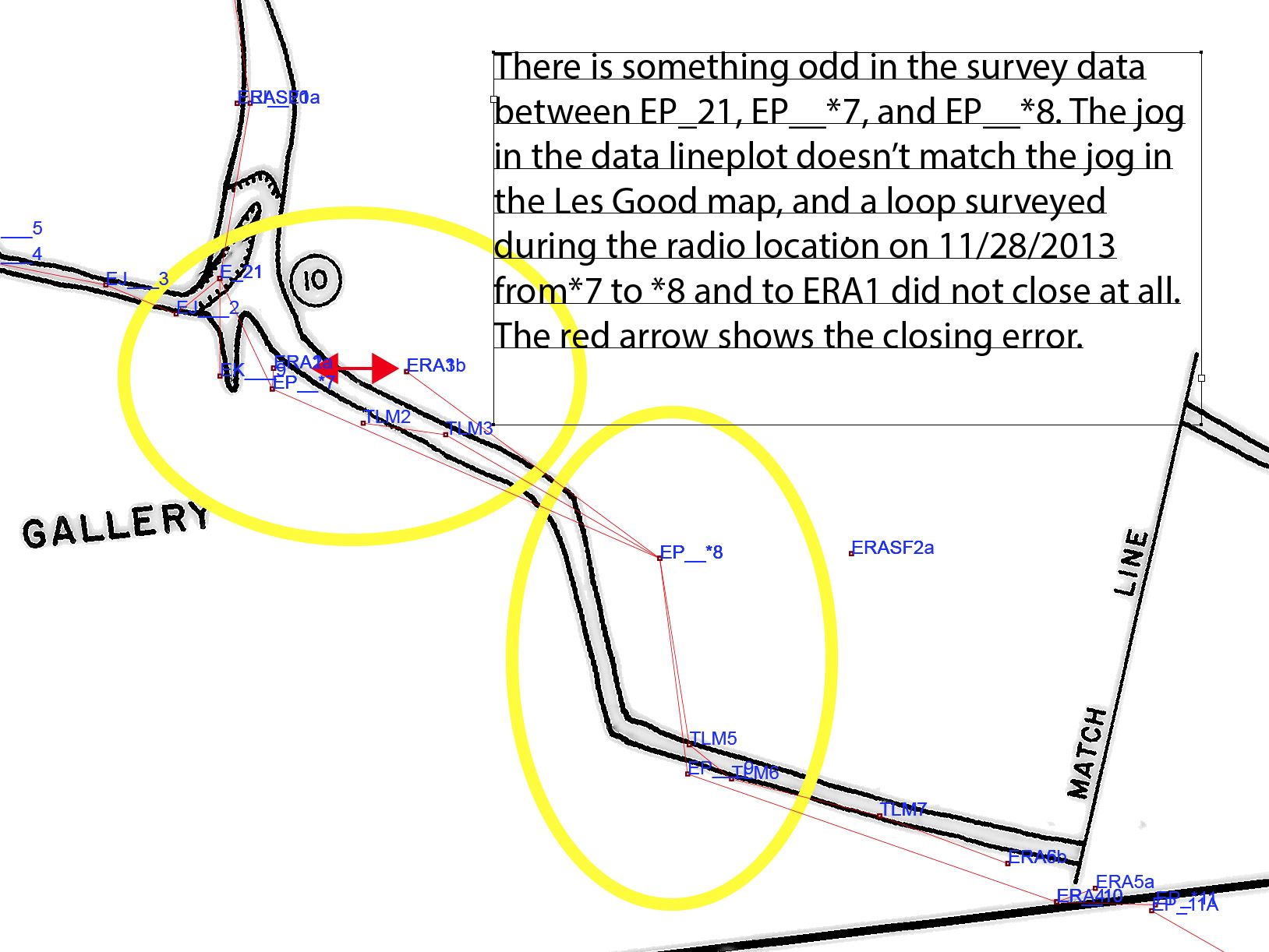
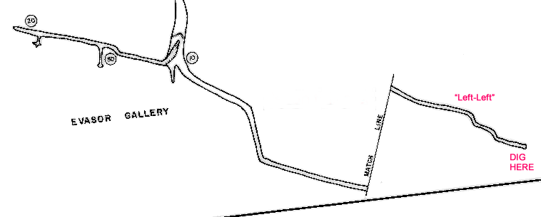
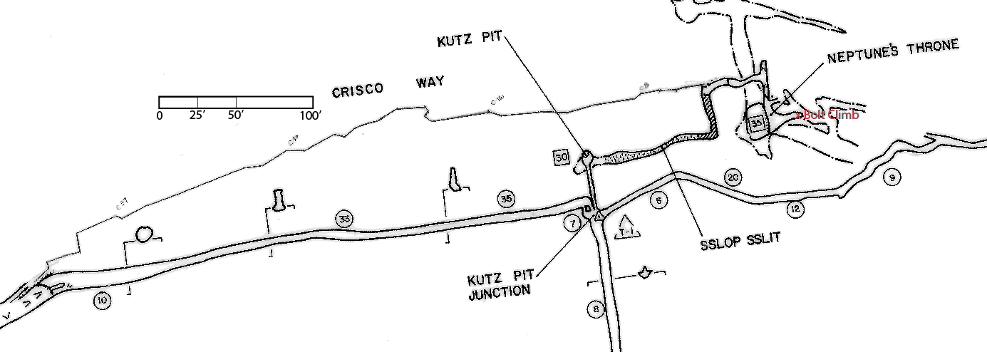
BL-3. "Left-Left Dig" in the South-East portion of Evasor Gallery -- posted 10/31/2010, updated 6/11/2011 NOT FINISHED
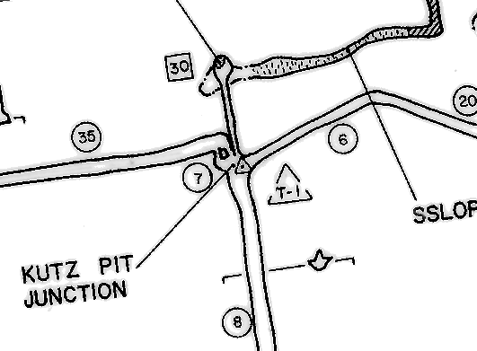
There is a very old dig with some air in the southern passage in Evasor Gallery, especially the SE end that heads towards Backyard Cave. We call this area "Left Left" because you turn left when you hit Kutz's Pit Junction and then left again when you hit the T junction shown below. This area was shown to be connected by air to Backyard Cave on 11/20/2010 (BL-1)
While you are there, there is some data funkiness in the data at the T-junction and heading out to the left-left; a few shots are needed to clean this up please.
Ed Kehs, Scott Molnar, and Andy ?unknown? checked this out 11/20/2010, and report a dig worth digging. It will likely require mining. And Nevin has an air connection with Backyard Cave here. Ed Kehs has planned to start mining Memorial Day Weekend 2011 but the trunk passage was flooded.
There were rumors that Ed Kehs led a Greater Allentown Grotto team to work on this dig February 2013, and that they declared the dig either too much work to widen the approach or too dangerous.
What's left to do?: Take dirt digging tools and other implements to enlarge the approach to the dig face. Assess the dig lead for shoring needs. Make a plan to seriously work this.
BL-5. The Bottom of the Bean Room - posted 1/6/2010. Updated 12/28/2015. STARTED, *ALMOST* FINISHED.
Believe it or not, the bottom of the Bean Room has not been completely surveyed, leaving many loops unclosed. I've highlighted this in pink, and thanks Nevin for pointing out this opportunity. On April 24, 2010, most of this survey was completed and many loops closed by Nevin W. Davis, John Sweet, Jean Vargas, and Nathan Farrar, here is John's trip report. Here are scans of the 4/24/2010 surveys. For these surveys, please reference this overview map and this detailed map. On November 16, 2013, Kiya Riverman, Paul Winter, and Tony Canike connected the lowest end of the Bean Room to the Difficulty Creek Passage, closing the biggest loop in this area.
What's Left to do? Nathan Farrar reports that there is also a connection from station 10 in the Bean Room to station SEG25 in SEG Passage, and that it might need a little cobble-moving to connect it. This would close another nice loop, provide another route to the Bean Room, and help us sort out the multiple overlapping levels of cave in that area. Here's a detail map.
BL-12. Dig Open The Air Dig - posted 1/6/2010, updated 6/25/2016. STARTED, NOT FINISHED.
In 2009, Keith Wheeland showed Nate Walter and Tony Canike this long-dormant but very promising dig. Nate and Tony wriggled head-first down a 10' sand crab tunnel to the face; it was so tight we could only push handfuls of dirt out past our hips. Since then, the digging has been going strong and it's become quite a feat of engineering. Significant progress--100's of feet--has been made 2009-2016. Easy digging, close to entrance, dry conditions. It's heading into a blank spot on the map. Phil Lucas installed an amazing tram to move the dirt out. And yes, there is air. Needs a team of 6-8 people to dig and move dirt, easy to get 100 buckets in 8 hours. This dig was written up in a report by Canike about a January 31, 2009 trip. Also see the 1993 BCCS Newsletter (V19, p15 of the 2009 digital reissue) for a trip report about the Air Dig and the sand crabs. More trip reports are here.
Could combine BL-12 and BL-48.
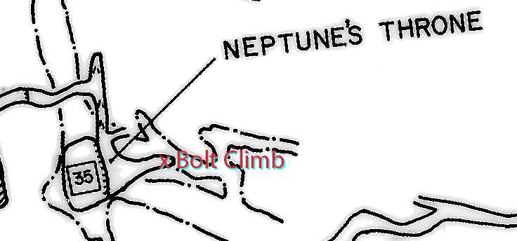
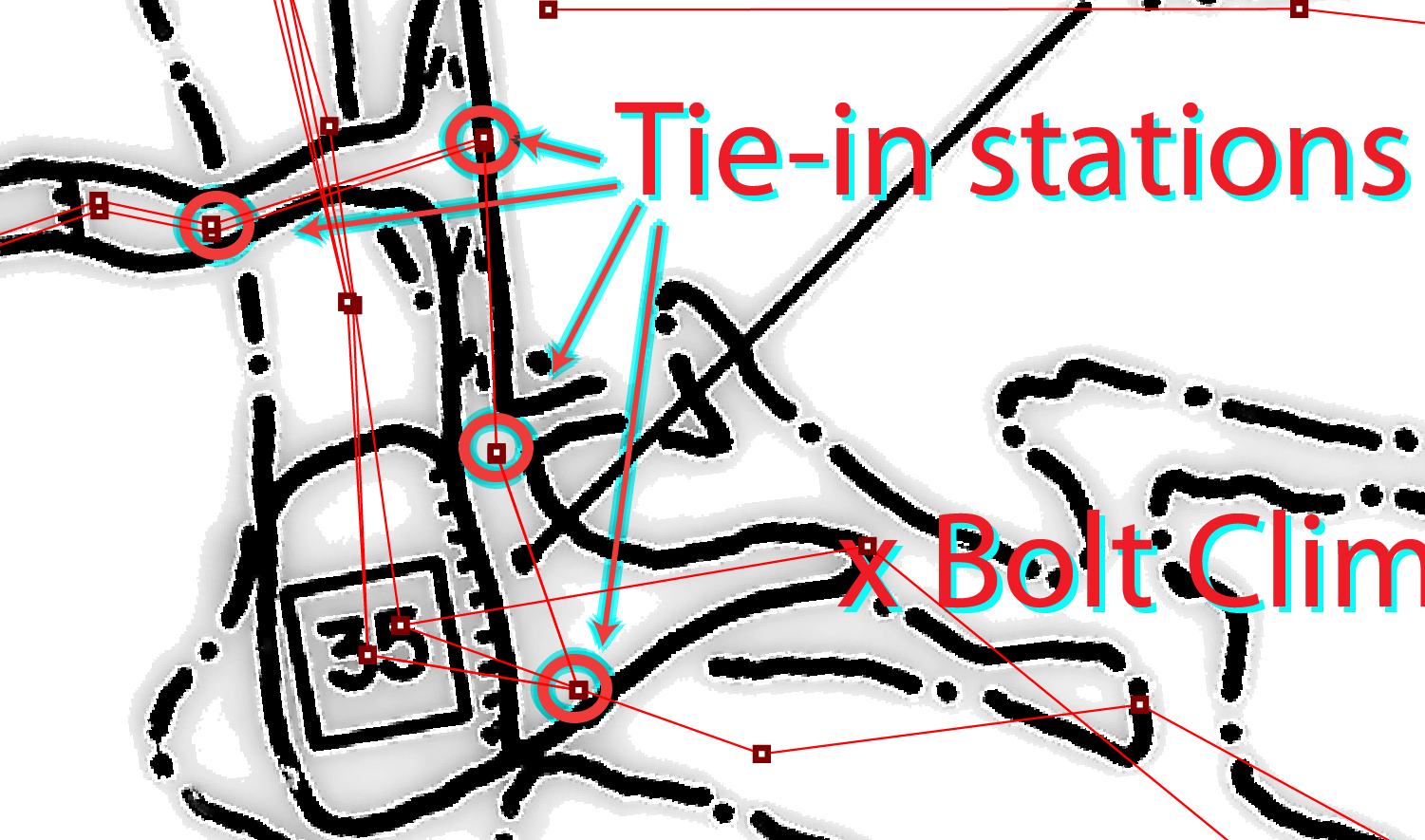
BL-13. Neptune's Throne Bolt Climb - posted 10/31/2010, updated 12/28/2015. NOT STARTED
On August 8, 2010, while Nevin W. Davis and Tony Canike were setting a bolt, Nathan Farrar found a bolt climb lead in a side passage at the top of Neptune's Throne that is not shown on the Good maps. On that August trip we were dropping Neptune's Throne, and we left a static rope at the top of the throne that can be used for this climb. Trip report here.
On November 7, 2015, the Neptune's Throne drop down to Marlboro Country was permanetly rigged on new stainless bolts, and the static rope that was left in August 2010 was again left for the bolt climb and in case a second rope was ever needed for the Neptune's Throne drop.
BL-15. High Leads between Elephant's Graveyard and Ike's Fissure -- posted 6/11/2011, updated 7/19/2014. NOT STARTED.
Mark Minton noted a couple more good leads on the 7/3/2010 trip. The leads are on the Elephant's Graveyard end of the "Ike's Fissure" crawlway. Here is Mark's Trip Report.
And notes from Mark Minton on 2/18/2016: "There are definitely leads there, but I wouldn't say they're great. Could go, but most likely they're just upper level fissures. Definitely worth checking, but I'd have a backup plan in case they crap out right away. Also, be sure the team has good climbers. Some of those leads are rather exposed."
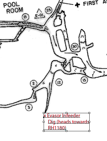
BL-16. Evasor Gallery In-feeder Dig -- posted 10/31/2010. UPDATED 3/2/2016. NOT FINISHED.
There is a long standing dig in the Evasor Gallery In-feeder stream right off the Pool Room. Nate Walter had been periodically taking people to this dig for a few years, but hasn't been back since about 2010. Lookup the trip report by Canike from January 31, 2009 about a visit to the dig. It's going in a very good direction...towards Back Yard Cave, RH 1180, and perhaps Barberry and CRCS (ok the last one is a bit of a stretch.) Nate reports finding bits of trash in the dig from time-to-time, presumably washed in from a sink hole used as a trash dump.
Update 3/2/2016: Also, there's a stream flowing in Rat Hole 1180 -- is this the continuation of the RH 1180 stream? RH 1180 has 499' of surveyed passage, would be a nice add to Butler.
BL-17. Evasor Gallery Bolt Climb "Cock-Eyed Climb" - posted 12/1/2010, updated 6/1/2011 and 8/12/2011. STARTED NOT FINISHED.
On 11/20/2010, Nate Walter, John Groh, and Terrance Lovell surveyed the "President's Regret" passage (see trip report emailed to BCCS list) and found (or refound) this climb. On January 8, 2011 Tony Canike, Nate Walter, Jean Vargas, and Brad Cooper did the first half of the climb (see that report emailed to the BCCS list.) Tony and Nate planned to go back and finish over Memorial Day weekend 2011, but were stymied by sumped Butler main trunk passage that resulted from the May 2011 rains. On July 3, 2011, Maret Maxwell, John Groh, and Tony Canike returned to the climb. A hand-line was rigged over the canyons leading to the climb, and the climb was continued upwards until thinly-bedded limestone with shale (?) layers was encountered. Longer bolts will be needed to finish this climb. Read more in the trip reports.
What's Left to do: Go back during very non-neutral weather and check for airflow to see if this is worth pursuing further. Perhaps have Nevin open the gate to Back Yard Cave in the chance it might improve airflow. Retrieve the bolt hangers left in 2011.
BL-18. Downstream Trunk Channel Bypass - Upstream Dig - posted 6/10/2011.
Keith Wheeland has been scratching at two digs in the Bypass passage off the main trunk channel downstream. The "Bypass passage" bypasses the low wet area in the trunk stream channel, and is shown as sketched in on Les Good's Section 5 (4/90 revision.) This first dig is in the upstream section of the bypass. On Les's map, it is the bit of passage that points downward on the paper (SE mag). Keith Wheeland, Nathalie Hirneisen, and Ed Kehs dug here on the 4/24/2011 Expedition Weekend. Last reported activity was digging by Nate Walter, Maria Andrews, John Groh, and Tony Canike on January 22, 2011 Expedition.
BL-19. Downstream Trunk Channel Bypass - Downstream Dig, aka "Gussey's Dig" - posted 6/10/2011.
Keith Wheeland has been scratching at two digs in the Bypass passage off the main trunk channel downstream. The "Bypass passage" bypasses the low wet area in the trunk stream channel, and is shown as sketched in on Les Good's Section 5 (4/90 revision.) This is the second dig, also known as "Gussey's Dig", and it has not been worked in a while. It is in the very downstream extent of the bypass, in the little passage that goes right on the paper (NE mag). Lookup the trip report by Canike from January 31, 2009 about a visit to the dig. Also see Keith's report of the Downstream Bypass - Dig in the BCCS Newsletter Vol. 9, p. 16, 1983
BL-20. South Crystal Gallery Dig - posted 6/10/2011.
Keith Wheeland has also been scratching at dig near the end of Crystal Gallery. It's an upward dig, pulling down cobbles from a drippy ceiling/corner. It's on Les Good's Section 2 (4/90 revision.), and is in area on the south with a ceiling height of 5' that shows breakdown blockage. Last reported activity was when Keith Wheeland took Tony Canike and a Nittany Grotto contingent there ca. 2010 or 2009.
There are other "goes" on Les's map in that area.
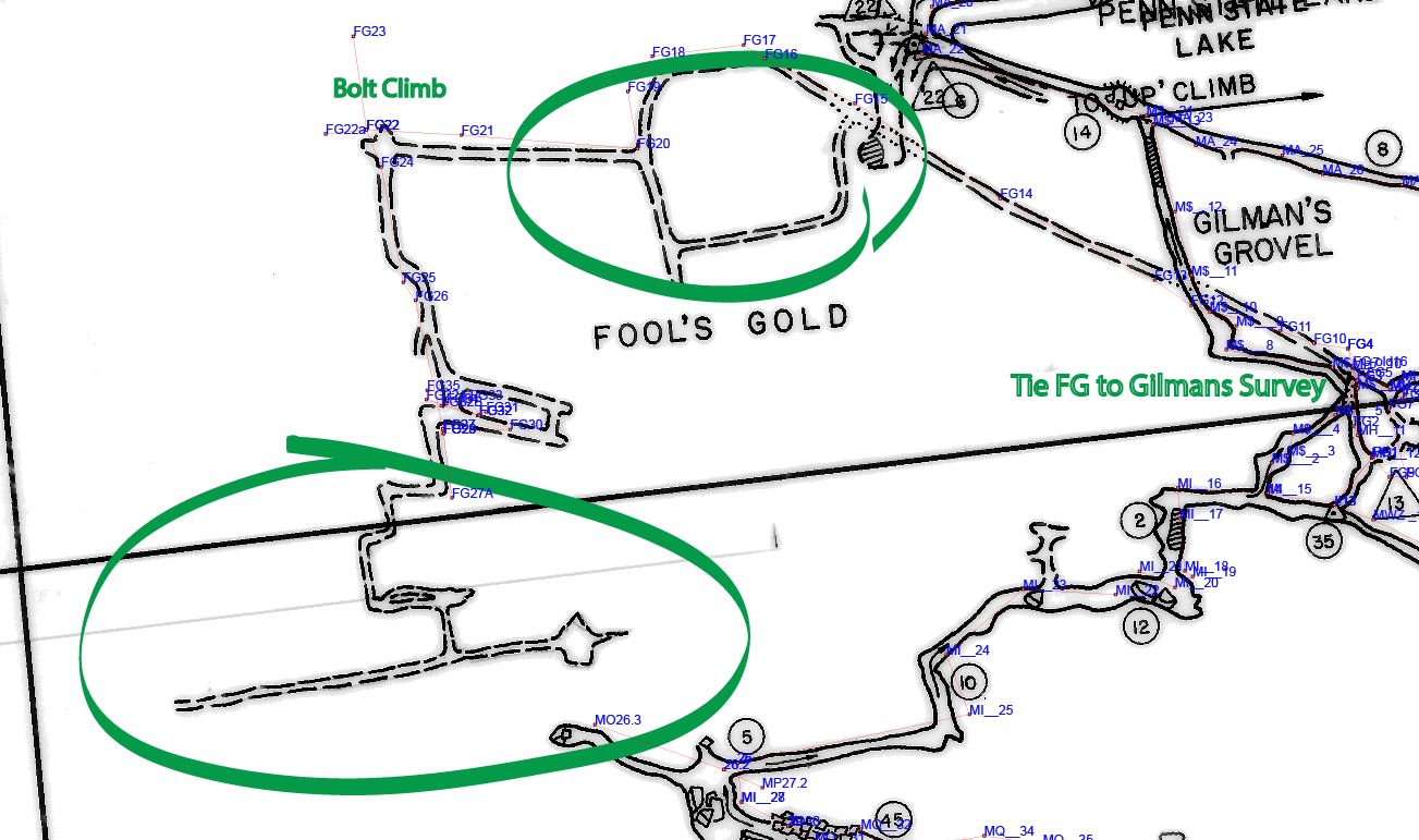
BL-21. Survey Fools Gold - posted 6/27/2010. Updated 12/09/2014. STARTED NOT FINISHED
As you can see on this map, the Fools Gold section beyond Penn State Lake Is missing survey data and needs a team to go clean this up. On 7/5/2014, a team of Bob Alderson, Eric Pelkey, Hope Brooks, and Tony Canike began the resurvey, here's the trip report.
What's left to do: here's the to-do list to finish this up:
- Reshoot !!13-FG1, FG1->FG2, FG4->FG10, FG6-FG7, FS&BS were close but not great. We were still shaking things out.
- Survey down from FG3 and/or FG4 to lower level. Perhaps it is Gilman's Grovel. If so, tie-in to survey of Gilman's (M$___6 and M$___7). If not, survey the lower level. You can probably check this out by going to 15 and climbing down (that's where the traverse line goes.)
- Resolve high lead near FG12.
- Survey the side loop FG15->FG20. (This is shown as sketched on the Good map.)
- Push down into pit near FG19.
- Bolt climb near FG22 and FG23.
- Get missing LRUDs (27A, 32A, 32B, 32->33, 35).
- Reshoot FG18->FG19,FG30->31,FG31->32 FS&BS within 3 deg, need w/in 2.
- Tie into old A1 in carbide near where we stopped surveying and where we found the little water bottle. Think it's FG27 but can't tell. There's an odd note in the book on FG22 about A1.
- Tie in our FG35 back down to FG26 or FG27.
- Push the ends of Fool's Gold past FG27 and survey. (There's more passage shown sketched on the Good map.)
- Find the “tortuous lead to an impassable squeeze” reported by Rod Riley, Buddy Jackson, Robbie Nicholson, Mike Artz, and Bob Carts on their trip during Expedition 37 (September 19, 1981).
- Do some climbing around high and low leads.
- Get a couple more tie-ins to the 2nd set of old stations (the !xx numbers) we found back in the cave. There is some old floating survey data for far out there.
Here's an annotated map to help explain the above.
BL-22. Lead in Ceiling at C19 - posted 6/27/2011. NOT STARTED
On Section 8 of the Good Maps, there is a note "lead in ceiling, bolt or pole" near station C19. Late night fireside conversation with people who were there 20+ years ago say just a couple bolts would be needed to get up there.
BL-23. Fred L. Wefer Memorial Highway - posted 6/27/2011. NOT STARTED
It is tight and narrow, but Keith Wheeland reports that the wind blows through there. There is a note on Sectional #8 of the Good Maps "Dig - Air". What more do you want? Keith used the word "wind". Come on now, how can you be proud of yourself and not go work this one? It probably needs some shaving to make it workable. Could get us over the sump....
BL-24. Gussie's Poke Hole - posted 6/28/2011. NOT STARTED
Gussie's Poke Hole is located on the right side of the Sinking Creek trunk passage as going downstream, just downstream of Pat's section. Climb up a little slope about 8 feet and you can see through the Poke Hole into a little room and/or passage. The Poke Hole is an oval about 8” in the vertical and 14” in the horizontal directions. Take a hammer, chisel, and crowbar to remove a little flowstone to make it passable. Lookup the trip report by Canike from January 31, 2009 about a visit to the dig.
Could combine BL-24, BL-50, and BL-51 as they are near each other and there might be some confusion.
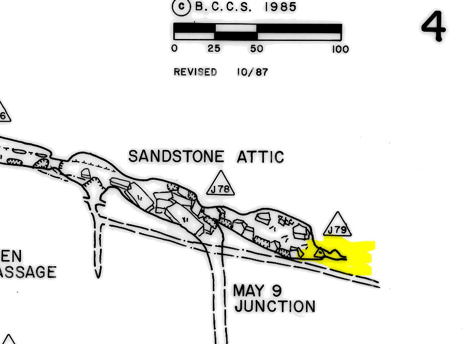
BL-25. West End Crystal Gallery Dig - posted 6/28/2011. NOT STARTED
There is also a long dry crawlway at the very end of Crystal Gallery, headed towards the Sandstone Attic, that has been dug on in the past. Station 35 is marked on Les's map (sectional 2) just next to it. Nate Walter has notes from a trip in 1991 or 1992 that read 'blast or hammer and chisel ??". Nate suggested in an email on 1/12/2011 that hammer drill, straws, and a sled would be needed.
The last surveyed station in the dig is station 37, which is only 116.4' away (horizontally) from station J79 in the Sandstone Attic,and the Sandstone Attic and West End passages line up nicely on line running SW to NE. Alas, the survey says station 37 is 115.8 feet below J79 (maybe there's an error in the vertical control?) See BL-44, and BL-45 for more about the Sandstone Attic and Sandstone Basement.
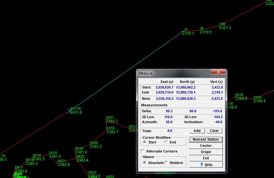
BL-27. Bicking Resurvey & the Wind Dig - posted 7/17/2013. STARTED 7/5/2013. Updated 12/28/2015. NOT FINISHED.
Update: The Wind Dig has been broken through on February 22, 2014, we connected to historically known passage that we lacked data for, and the (re) surveying of the passage beyond began on March 14, 2014. We've run a few survey trips, and there are about 500' of cobble floored stream crawl to enlarge and (re)survey. On Les Good's sectional map #3 (marked 10/87), at the junction of the Towards Boundless and Birthday Passages, there is a lead marked "too tight strong wind". Mark Minton, Vonny Droms, and Tony Canike reconnoitered the dig and began digging on 5/26/2013 (report here) and 7/5/2013, and there were two more dig trips on 7/5 and 7/6/2013 (trip report here.) After the 5/26/2013 trip, we hypothesized potential shortcuts to the Rotunda Room, which resulted in BL-26, which is completed.
What's Left to do? There is historic passage left to resurvey as we have no data for it, or the data was of too low a survey grade to use. Contact the project lead for more information.
BL-28. Gussey's Secret Climbdown to the Bean Room - posted 7/17/2013. NOT STARTED
Gussy (Keith Wheeland) reports a Secret Climbdown to the Bean Room that needs to be surveyed. There are reports of pretties. Here's Keith's description from a private email 7/17/2013:
It is possible to free-climb down from the Step-Across to the bottom of the Bean Room and back up, without a handline. On the way you will see the only [example of this type of pretties] that I know of in Butler Cave. Climb down the Step-Across and take a hands and knees crawl back toward the Bean Room Step Across. The passage will be on the left of the passage to the Bean Room Step Across. The passage looks like it dead-ends, but upon getting closer to the apparent end, you will see a hole in the floor. It is a vertical squeeze that emerges at the top of a flowstone slope. One can use the also sloping ceiling as a hand bracing bridge. The slope ends at a narrow canyon that one can climb down to the passage floor. As one emerges out of the vertical squeeze the [pretties] will be on the right on the slope. Hundreds of tiny[pretties] line the edge of the passage in the bottom of the Bean Room.
Note: The specific type of pretties has been withheld by the editor to encourage completion of this survey!
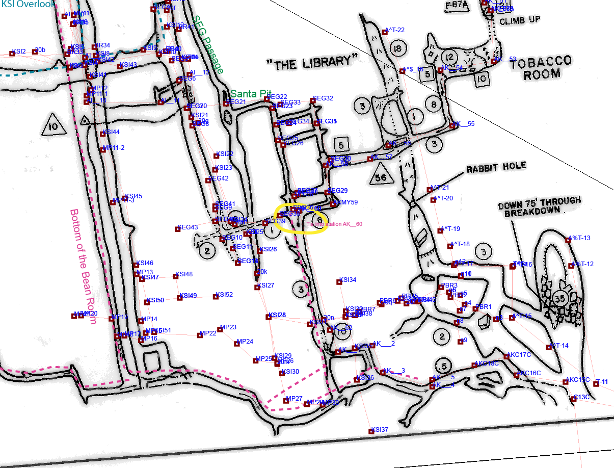
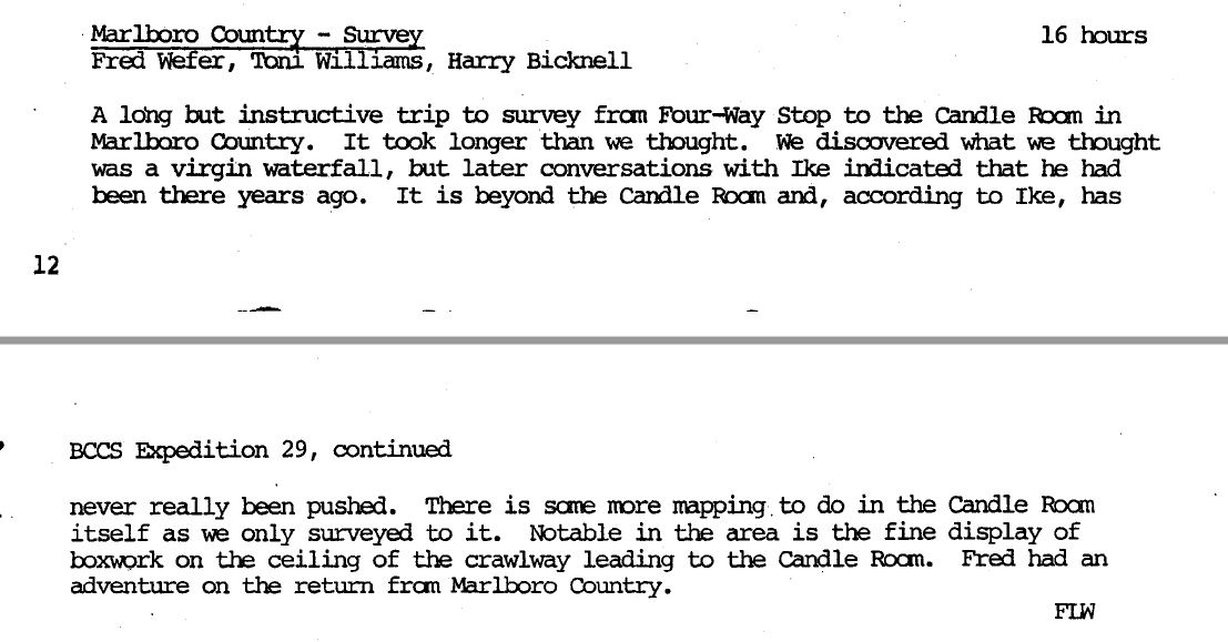
BL-29. Survey the Good Way to the Candle Room - posted 9/21/2013. Updated 1/16/2016 COMPLETED 2016-11-12
The Good Way climb down to the Candle Room, avoiding Neptune's Throne, has not been surveyed. This is important as it will close a big loop (with a perimeter of over 5700 feet) across two levels. Here is a little map. And another little map.
In late 2014, Eric Pelkey noted that the survey to the top of the climbdown (FIDS) appears to lack vertical control, so you would need to start at DS_3 or DS_4 for a tie-in and resurvey to the climbdown. On 9/19/2015, Hope Brooks, Kathleen Kerrigan, Eric Pelky, and Tony Canike corrected this lack of vertical control. We surveyed from DS_3 in the Christmas Passage and set 10 stations to the top of the Good Way climbdown to fix the missing vertical control to the top of the Good Way. We did not climb down. Trip Report here.
On November 14, 2015, a team of VPI cavers led by Tony Canike, rigged the climb down with a 9mm rope and surveyed from the top of the climb down (where the 9/19/2015 survey ended) to the passage below, and then for a few hundered feet towards the Candle Room, but were not successful in finding marked stations without surveying all the way to the Candle Room. So the loop remains unclosed.
<need details, but Nick Socky led a team to finish this in November 2016. leaving here until we get the trip report.>
Combine BL-29, BL-33, BL-41, and BL-46.
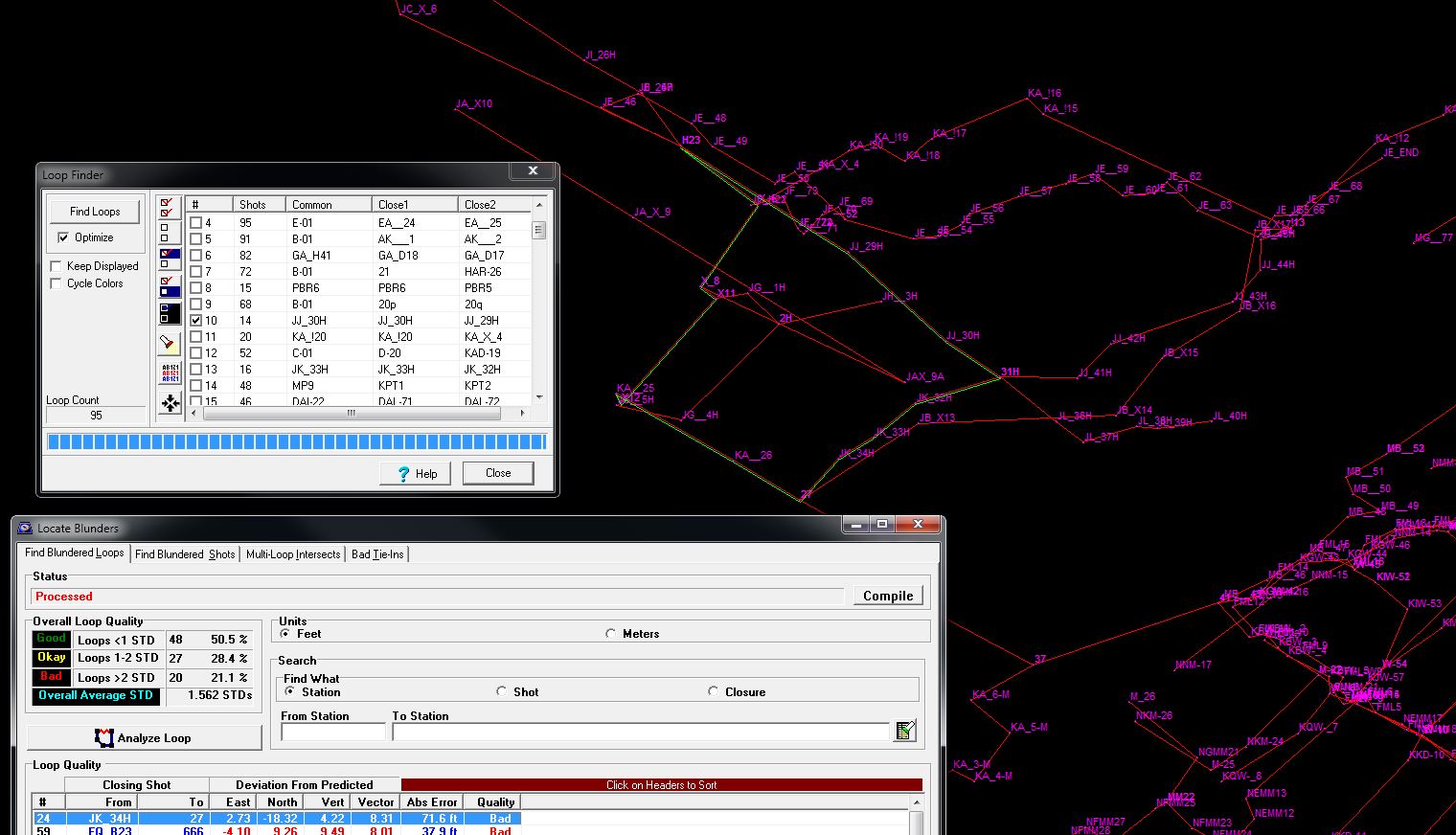
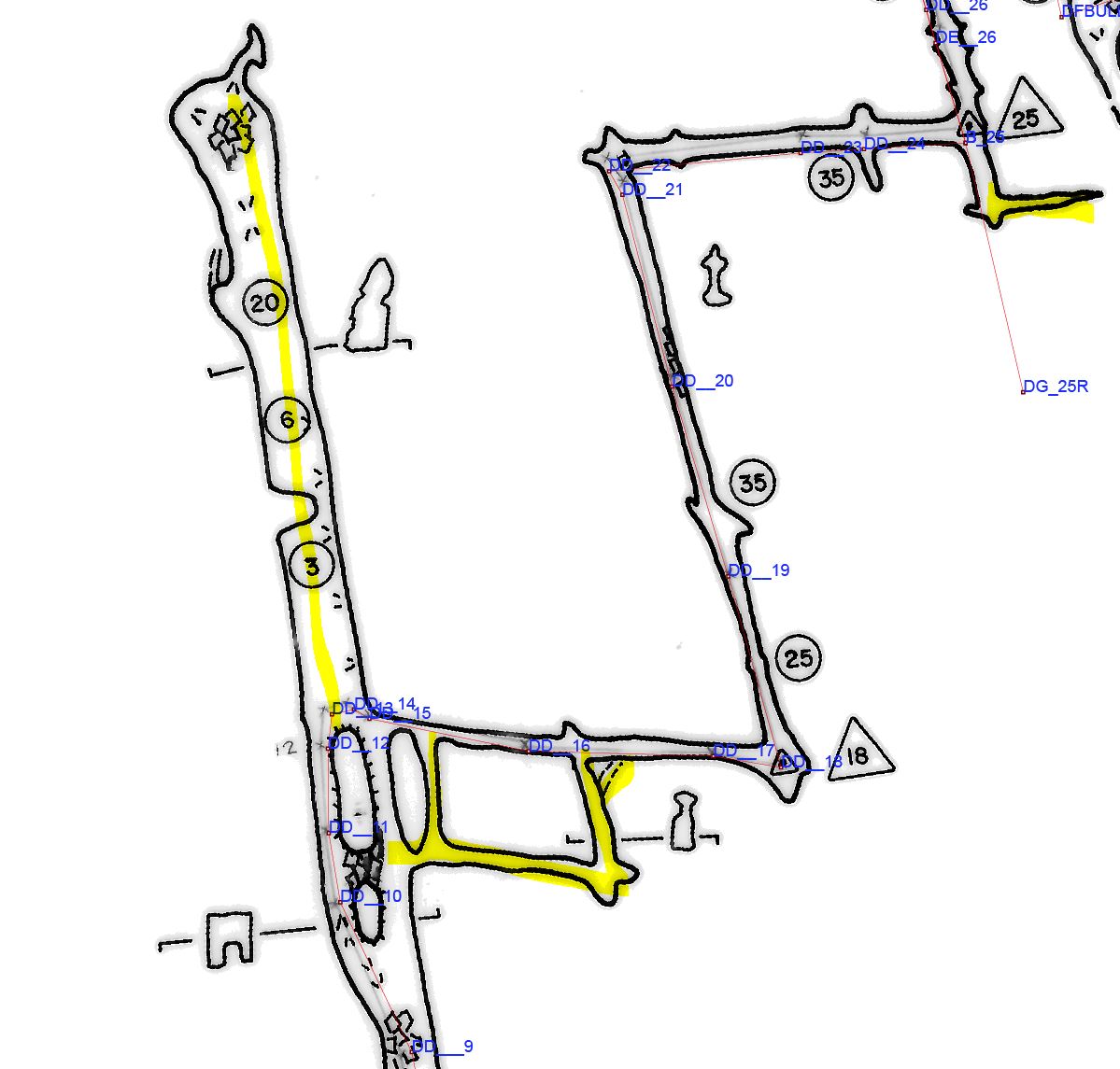
BL-30. Analyze and fix bad loops in the Upstream Maze - posted 9/21/2013. One loop resurveyed May 2014.
According to the Compass-generated loop close errors, the Upstream Maze and beyond have the worst loops in the cave. This needs careful analysis to determine what to resurvey, and then that needs to be resurveyed. The worst loop in the cave is in the general area between Huntley's and Squashed Boob Squeeze. This is important as it will improve the line plot and fix errors in the survey data. Also see BL-36. Hope Brooks lead a team in over Memorial Day weekend and resurveyed one loop, but many more bad loops remain to be resurveyed.
See BL-65 and BL-66 for specific suggestions.
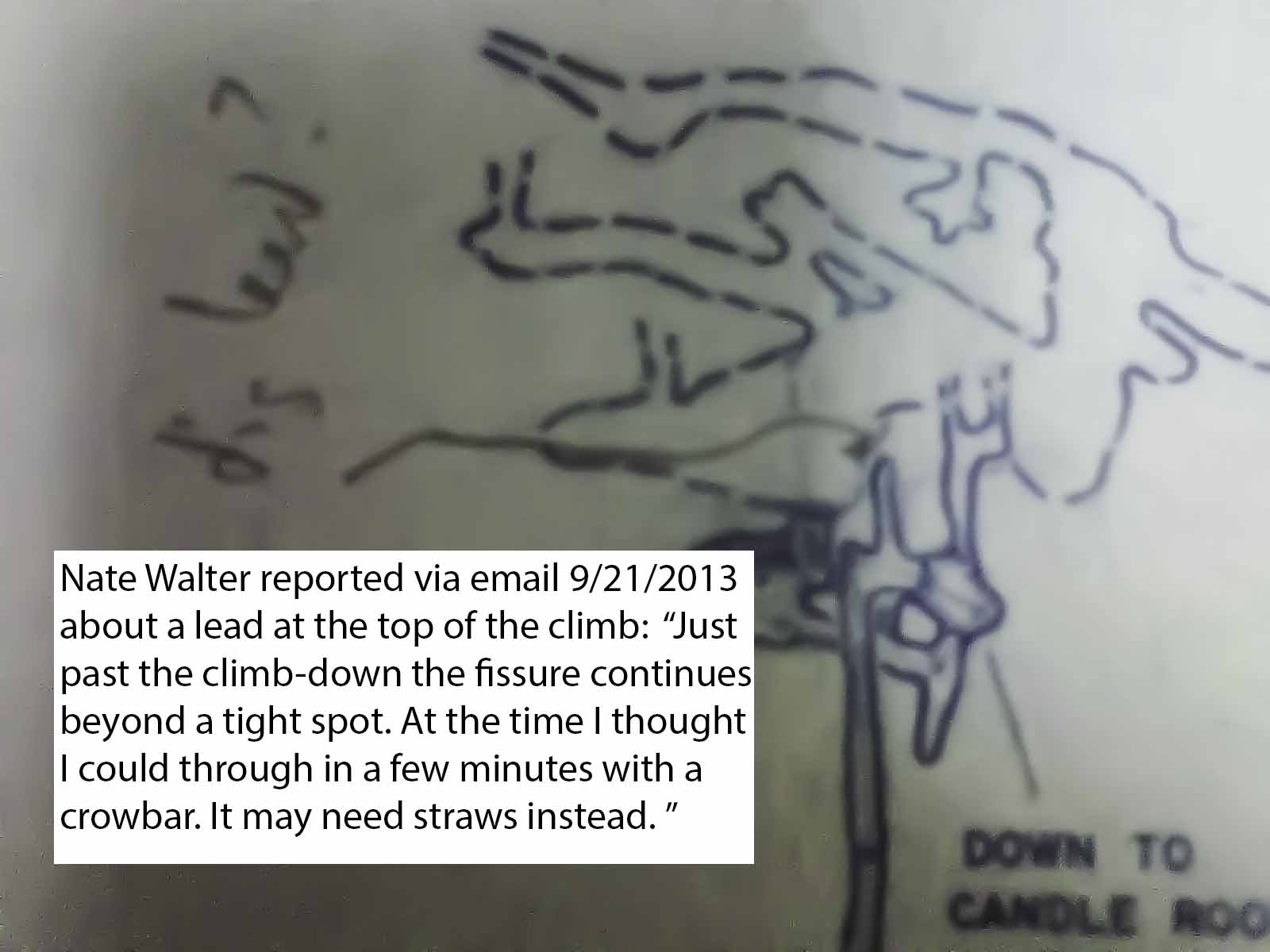
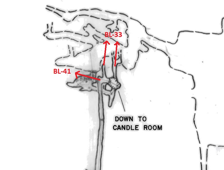
BL-33. Dig/Push/Enlarge fissure at top of the Good Way - posted 9/21/2013. UPDATED 9/21/2015 NOT STARTED
Just past the Good Way climb-down, the upper level fissure continues beyond a tight spot. Nate Walter reported in September 2013 "At the time I thought I could get through in a few minutes with a crowbar. It may need straws instead." From his description it appears to head off at an approximate bearing of 310 deg mag. Here is a map. And another little map. A scouting trip on 9/19/2015 with BL-29 as the main objective revealed a number of leads to check out. For example, there is one unsurveyed passage of a couple hundred feet that is filed as BL-41. Trip report here.
Combine BL-29, BL-33, BL-41, and BL-46.
BL-34. Pants Off Crawl Hammer & Chisel Lead - posted 10/21/2013. NOT STARTED
Just past the Pants Off Crawl on Section 7 of the Good Maps, there is a lead marked "Hammer and Chisel Lead." More than one person has suggested that a couple straws could make the Pants Off Crawl much easier too.
BL-35. Maret's Madness Dig - posted 10/21/2013. NOT STARTED
A little further past Pants Off Crawl, andjust past BL-34, on Section 7 of the Good Maps the end of Maret's Madness is marked "Goes - Dig". You'll have to ask Maret.
BL-36. Missing Survey in Huntley's Cave. NOT STARTED
There are a lot of unsurveyed passages in Huntleys. We could easily add a few hundred feet to the surveyed length of Butler Cave. See BL-30.
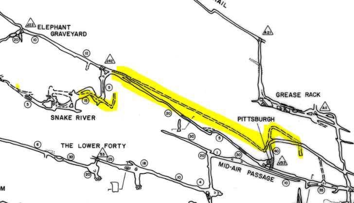
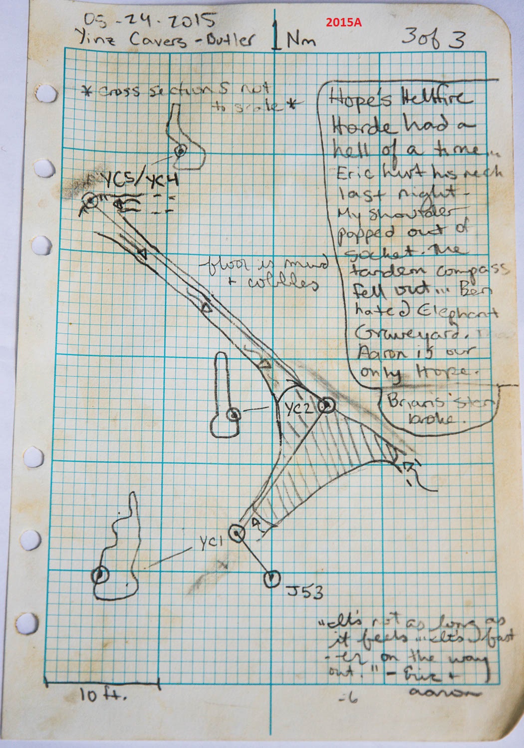
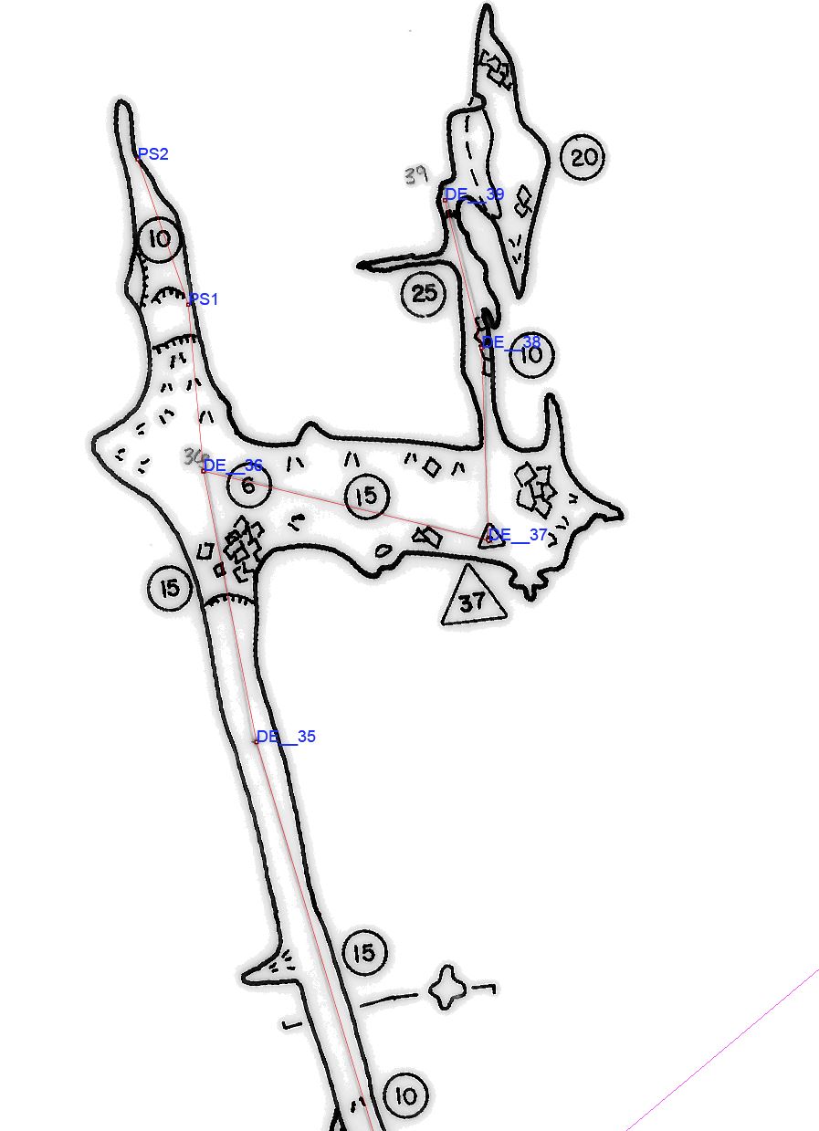
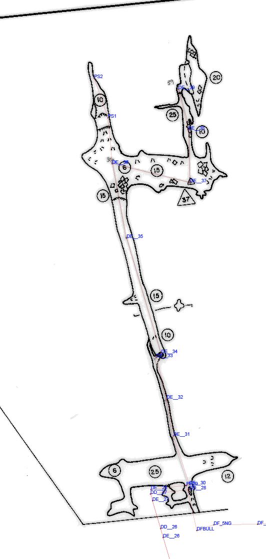
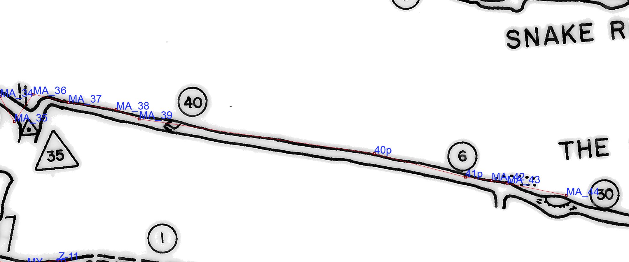
BL-37. Unsurveyed passage between Snake River and Pittsburgh ADDED 2014-08-10 UPDATED 3/2/2016. STARTED NOT FINISHED.
There is a sketched passage between Snake River and Pittsburge on Section 4 of the Good Maps. There is also a little bit unsurveyed in Snake River. We could easily add a few hundred feet to the surveyed length of Butler Cave.
Update: A team went to survey this on May 24, 2015, but their compass broke. Here is their survey sketch for your tie-in.
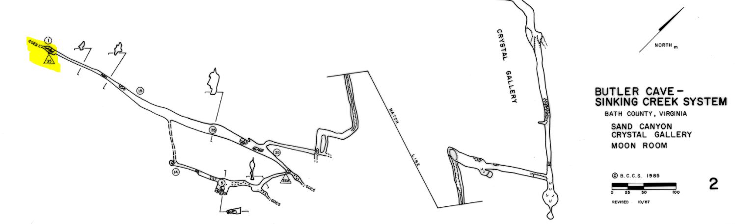
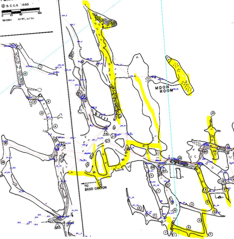
BL-38. Unsurveyed Passaged around the Moon Room and El Phallus del Toro ADDED 2014-08-15 UPDATED 7/09/2016 STARTED *very likely* FINISHED.
There are many passages in the general area of the Moon Room that have not been surveyed (map). For example, the passage up to El Plallus del Toro is not surveyed, nor is the back way out of the Moon Rom to the main trunk. There are a handful of other unsurveyed passages that need to be mopped up too. BE VERY CAREFUL, there are many sensitive sections with delicate formations.
On November 14, 2015, a team of VPI cavers lead by Paul Winter mopped up some missing survey in the passage from the Moon Room up to El Phallus del Toro. There is still much passage to resurvey. When we get the notes scanned and the survey data processed the map will be updated.
On July 3, 2016, Paul Winter lead a team to mop this up. We believe this lead has been killed but we are awaiting final analysis of the data.
BL-40. Resurvey Lower Complaint ADDED 2015-05-19 UPDATED 2022-03-28.
The goal of BL-40 is to fix the survey data for the lower level of Complaint, as it appears to have many problems, and it is not tied into Upper Complaint. The drop from the upper level to the lower level is marked on a working map as "drop to lower level - rig and tie in survey". It has been rigged, but the survey is not tied-in. Following this annotated map, start from station C in Dave's Gallery, go up through the crawl in the upper level of Complaint, tie in to C32, survey to and down the now-rigged drop, tie into any old stations you find,and survey out to Sand Canyon and tie into B-01 by the first aid kit.
Progress:
- Feb 20, 2016: Sand Canyon to the entrance of Lower Complaint [B01 to AYG5] was surveyed in by Hope Brooks, Dianna Orndorff, Megan Junod, Jenn McGuire, Eric Pelkey, and Tony Canike with the "Air Your Greivances" survey filed as 2016B.
- Feb 20, 2016: Upper Complaint to Lower Complaint [32 to DWC10] was surveyed in by Hope Brooks, Dianna Orndorff, Megan Junod, Jenn McGuire, Eric Pelkey, and Tony Canike with the "Done With Consent" survey filed as 2016C.
- May 29, 2016: Much, but not all, of Lower Complaint [DWC10 to KLM24] was surveyed by Mike Broome, Ken Walsh, Lisa Lorenzin with the "KLM" survey filed as 2016F.
- December 10, 2016: The rest of Lower Complaint was surveyed to Sand Canyon [AYG5 to KLM24] by Aaron Clair, Mark Hodge, Joe Vance, and Noel Bond.
Remaining Work:
Survey from Upper Complaint back to Dave's Gallery. Tie into two stations at each end.
- Stations 32 and DWC1 in Upper Complaint.
- Stations "C" and another TBD station in Dave's Gallery. People working on BL-67 may have set new stations you can use.
BL-41 Survey unsurveyed passage at the top of the Good Way. ADDED 2015-11-01 NOT STARTED
At the top of the Good Way, there are a few hundred feed of unsurveyed passage heading off at a bearing of approximate 220 deg mag. Here is a map. And another little map. September 19, 2015 Trip report here.
Combine BL-29, BL-33, BL-41, and BL-46.
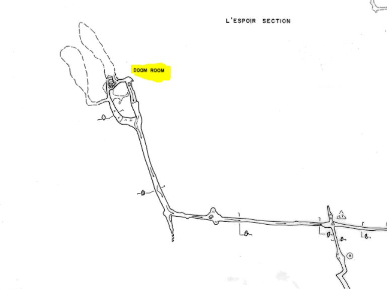
BL-42 Survey & Detail in the Doom Room. ADDED 2015-11-01 NOT STARTED
There is a large sketched area in the Doom Room (overview map). Survey and gather detail for that area (detail map with tie-ins.) Might need direct aid gear, Pete Carter and John Rosenfeld used tri-camps and nuts for direct aid. See trip reports in the newsletters from July 15, 1989 (in 1989 News) and april 13, 1983 (in the 1984 News.)
Could combine BL-42, BL-43 and BL-49.
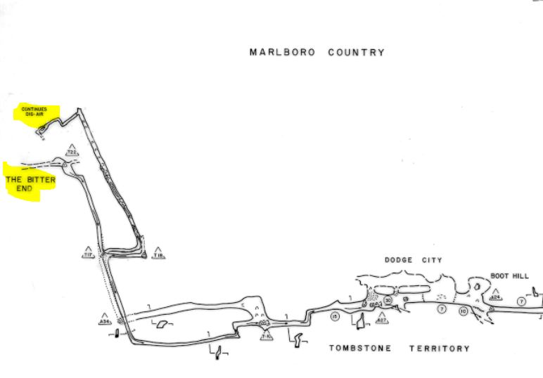
BL-43 The Bitter End and Dig with Air. ADDED 2015-11-01 NOT STARTED UPDATED 02-12-2017
The reason The Bitter End (overview map) ends is not documented on the map, and there is a dig with air marked on the map (detail map).
Update 2/12/2017: Nate Walter pointed out to me that the dig apparently breaches a sandstone layer; from a trip report by John Rosenfeld from 6/20/1987 in the 1987 BCCS Newsletter "Our team of four headed out to
the Bitter End to do a dig in
that blowing lead we found in
1985. We pulled out loose
cobbles from the low, muddy,
windy stream crawl for about
an hour. The lead is an uphill
dig of mucky slush and
cobbles which breaches the
lower Clifton Forge Sandstone.
We left a snow fluke digging
tool out there."
Could combine BL-42, BL-43 and BL-49.
BL-44 Sandstone Attic End Dig ADDED 2015-11-02 NOT STARTED
There is a dig at the very end of the Sandstone Attic. You need to hop up into a squeeze 4' off the floor. Unfortunately, you are standing at the top of a 20' hight dirt slope, with holes in the floor at the bottom of the slope. Not much to hold on to, you might want to set a bolt for a etrier or grab line. Might as well take straws out with you too. Here's a trip report from a trip with Jean Hartman, Nevin Davis, and Tony Canike on July 3, 2008. And here is a little lineplot showing the relationship to the Crystal Gallery. See BL-25.
BL-45 Sandstone Basement Survey ADDED 2015-11-02 NOT STARTED
The Sandstone Basement has some unfinished survey in it. Jean Vargas, Nevin Davis, and Tony Canike scouted the area looking for potential digs on July 3, 2008, we pushed a few but did not exhaustively push them all (trip report). In 1994 and 1995 Ed Kehs, Eddie Kehs, Becky Jones, Keith Christenson, Al Grimm, Mike Peters, Chris Kerr, Steve Yochum, and others ran three survey trips out to the area. Here are .zip files with survey notes from those three trips: 1994A 1995A 1995B and here's a working map that Keith Christenson drew.
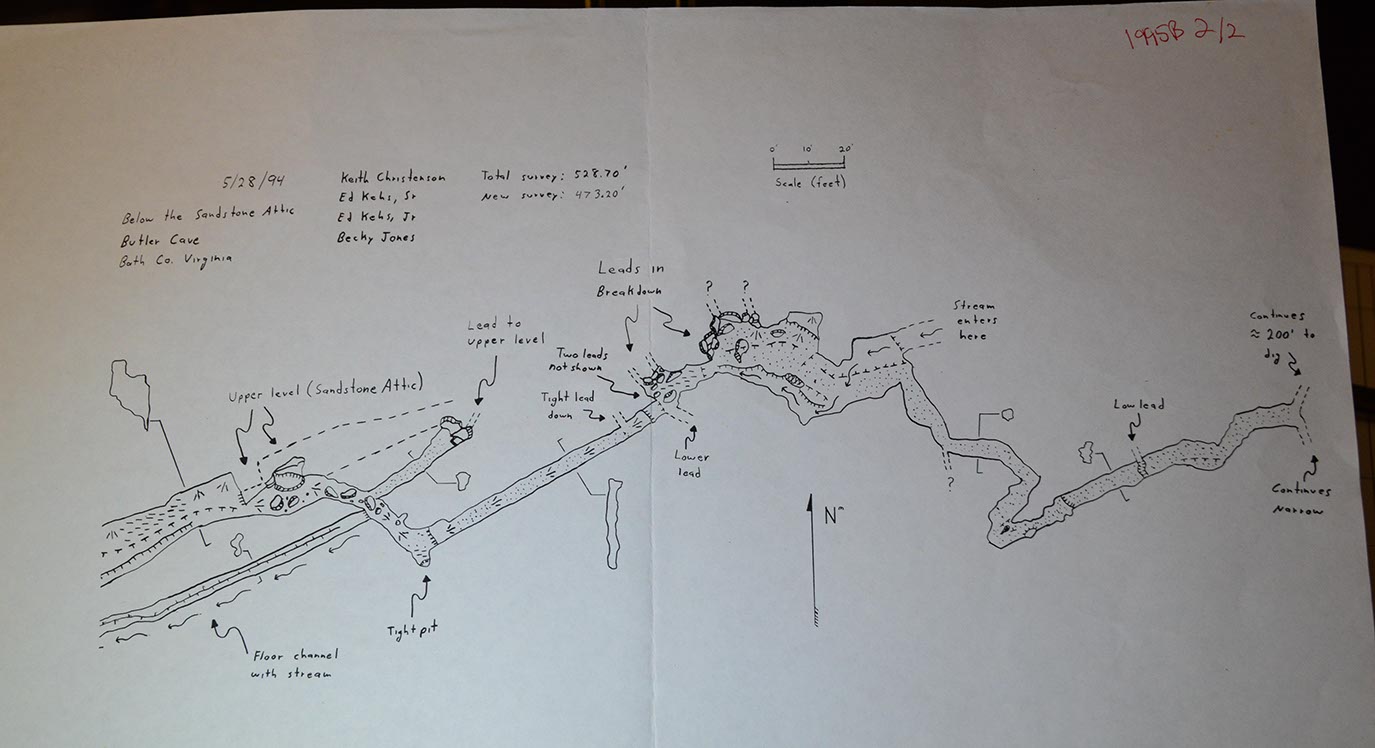
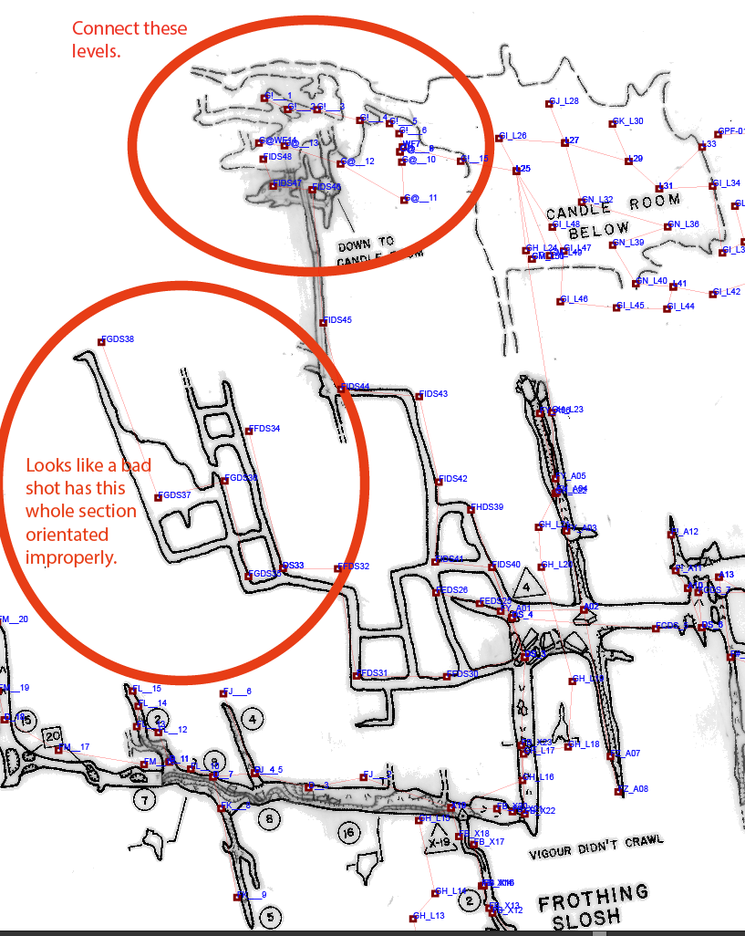
BL-46 Candle Room Resurvey and Lead Checking ADDED 2015-11-12 UPDATED 2016-01-16 STARTED NOT FINISHED
There are some leads on the map of the Candle Room and immediately adjacent area. Here's a little map.
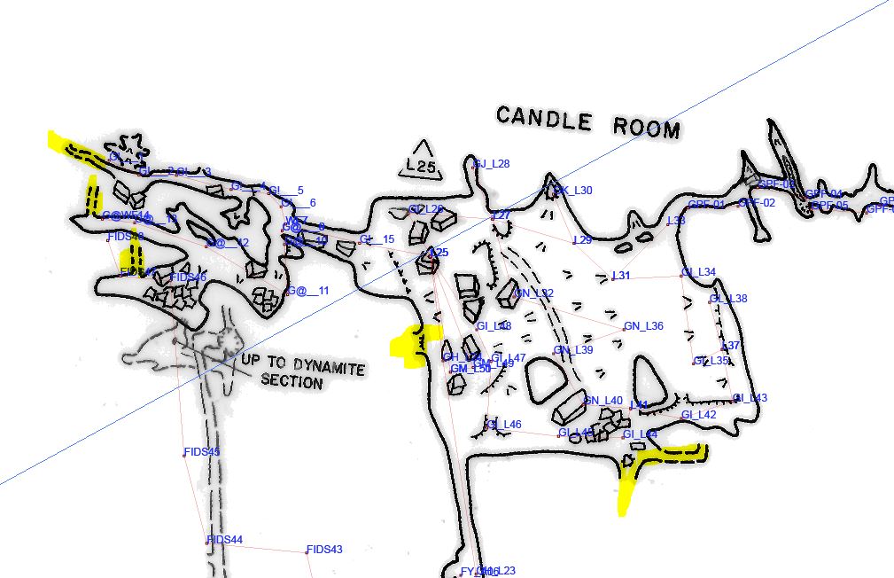
Nick Socky has been leading trips to complete the survey of the Good Way to the Candle Room (BL-29), and now that he and his teams have finished that, he's leading the effort to resurvey the Candle Room and check all the leads.
Could combine BL-46, BL-53, BL-54, BL-55, BL-56, and BL-57.
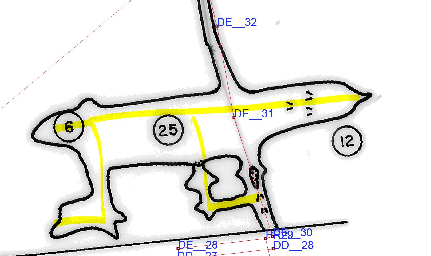
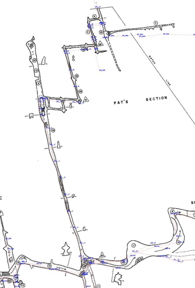
BL-47 Pat's Section Survey Mop Up ADDED 2015-12-09 NOT STARTED
There is some survey to mop up in Pat's Section. Note that part of Pat's Section has two surveys lines in it with very similar numbers, so please be very careful with the tie-ins. It's almost always best to tie in to multiple stations whenever possible, so if a tie-in mistake is made in the field, it might be recoverable with desk analysis. There are four detailed maps here: one two three four; and there are two overview maps here: one two.
BL-48 Survey Air Dig and and mop up around the Air Dig Up ADDED 2015-12-28. UPDATED 2016-07-09. STARTED, NOT FINISHED.
The Air Dig has been significantly extended since 2009, and the survey was never run to the face where we restarted digging in 2009. So the Air Dig itself needs to be surveyed. There is also about 50-75 feet of higher level passage that needs to be surveyed; it starts at the entrance of the passage leading to the dig and then heads NE (right on the Good maps) to reconnect to the lower trunk passage downstream. There is also one chunk of passage to mop up and then a few leads on the Good maps that need to be documented how they end. Map here.
In 2012 Jon Lillestolen and Molly Lucier surveyed much of the Air Dig, but did not get a good tie-in. In July 2016, Paul Winter and team tied-in the hanging survey.
What's Left to do? There is a upper level passage that runs from near the entrance to the Air Dig that reconnect downstream to the main trunk passage via a natural rock bridge that needs to be mopped up.
Could combine BL-12 and BL-48.
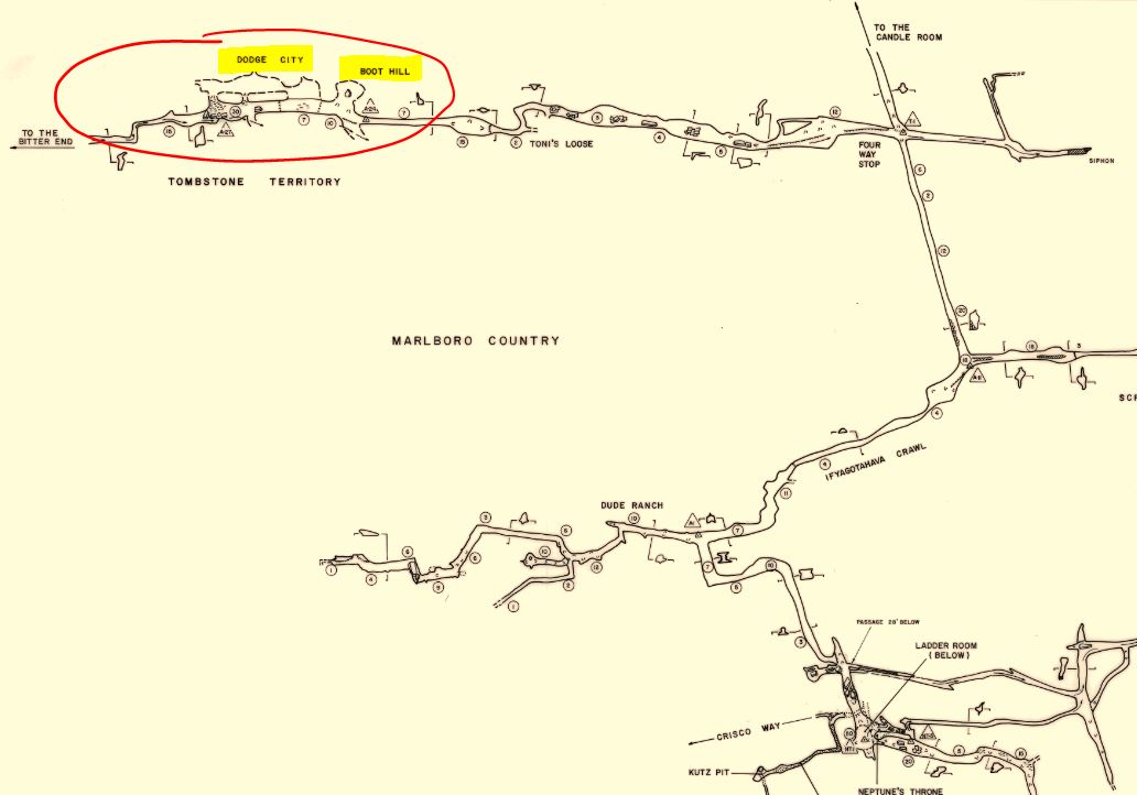
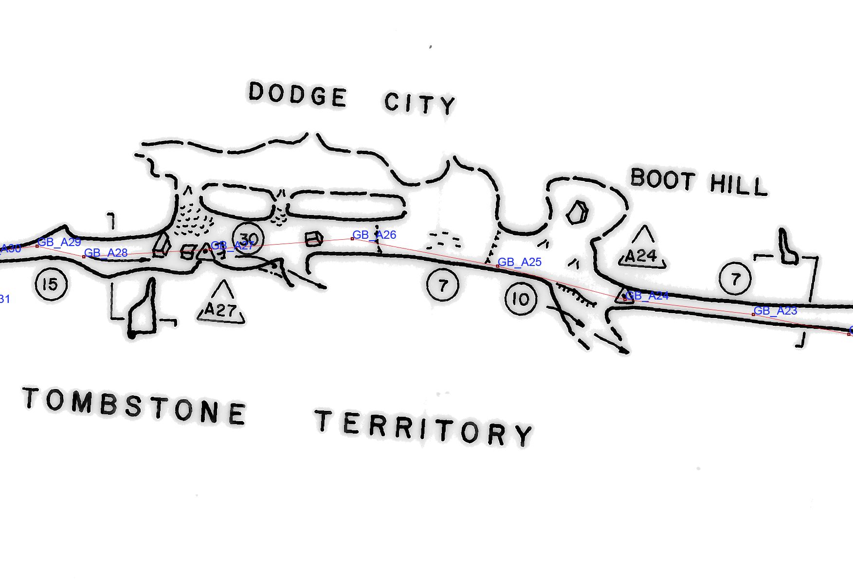
BL-49 Boot Hill and Dodge City ADDED 2015-12-28 NOT STARTED
There is a lot of sketched passage on Section 11 of the Les Good maps in the Boot Hill and Dodge City area. Go survey and nail it down. Here's an overview map and a detail map with survey tie-ins.
On February 11, 2017, Nate Walter recalled a trip from 1989 or 1990 with Jeff Uhl, Ed Kehs, Mike Kehs, Eddie Kehs and Nate when this may have been resketched. A search of the survey notes and Newsletters were unable to confirm Nate's memory.
Could combine BL-42, BL-43 and BL-49.
BL-50 Ceiling Dig Downstream of Pats ADDED 2016-06-25 STARTED 10/26/2013 and 11/16/2013 UPDATED 2016-07-09 *possibly* FINISHED
A team led by Bryan Crowell went looking for Gussie's Poke Hole (BL-24). About 40' downstream of the J-22 station on Sectional 5 of the Good Maps, they found a vertical fissure on the SE wall. That would put it near station DAJ-21.
From the 10/26/2013 trip report on p. 48 of the 2013 Newsletter: "Cynthia and Hope found a 10 foot long, 1.5 foot wide side “canyon” with a very lightly blowing lead at the top of it. The lead wasn’t quite big enough for the small girls to fit into, and you could see passage above, so we figured we had found the location." See the newsletter for the rest of the report.
Bryan led a followup trip to the lest on 11/16/2013, that report didn't make the 2013 Newsletter but will be published in the 2014 Newsletter. Bryan reported "Alex and I made one side of the fissure clean so we could maybe use it as a foothold in the future. We decided that the next trip would involve setting a bolt and hanging an etrier so that we could safely drill upward, since that is the way on."
Email reports state that this lead may have been killed, need to confirm.
Could combine BL-24, BL-50, and BL-51 as they are near each other and there might be some confusion.
BL-51 Cynthia Straddle Lead Downstream of Pats ADDED 2016-06-25 STARTED 10/26/2013 *possibly* FINISHED
A team led by Bryan Crowell went looking for Gussie's Poke Hole (BL-24). Instead they found BL-50, and then found this lead, BL-51.
From the 10/26/2013 trip report on p. 49 of the 2013 Newsletter: "The next lead was about 100 feet away [downtream of BL-50], Cynthia couldn’t quite straddle the dome lead that had slight airflow coming out of it to do the climb.....Cynthia’s straddle climb needs either a tall climber or, more likely, a bolt or two..... Nevin later said that he isn’t sure he checked the Cynthia straddle lead while pole climbing."
See the newsletter for the rest of the report.
Bryan led a followup trip to the lest on 11/16/2013, that report didn't make the 2013 Newsletter but will be published in the 2014 Newsletter. Bryan reported that Eric Pelkey may have killed this lead; we await confirmation from Eric.
Could combine BL-24, BL-50, and BL-51 as they are near each other and there might be some confusion.
BL-52 Dive and Survey Last Hope Siphon ADDED 2016-07-09
A "quick and easy" lead to add 1550' to the surveyed length of Buter! Last Hope Siphon has been dived, but has not been surveyed.
In 1976, Sheck Exley et al. dove Last Hope Siphon twice, and sketch mapped 1550' of passage, 600' flooded and 950' dry. It was not surveyed. He reported that Bad News Siphon was clogged with mud.
In 1980, Last Hope Siphon was dived again by Karen Wark, David Whall, and Maret Maxwell. They reported that the passage had more turns than indicated on Sheck's sketch, that the side lead is a small solution tube that has an interrminent stream, and that Bad News Siphon was still silted shut.
See the articles in the 1976 and 1980 Newsletters for more details.
As of July 2016, Zeb Lilly is planning on organizing a dive team and trip sometime in the 4th quarter 2016.
See this zip file for background information: BL-52 Last Hope Siphon Dive.zip
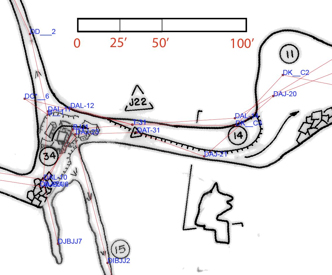
BL-53 Check three siphons off Candle Room for potential dives ADDED 2017-01-16
Check the three siphons immediately off the Candle Room for future potential dives. It may be visible from above the water that there is no possiblity of a dive. But take a mask and a good light, and be prepared to sumerse yourself for a 30 second underwater check.
1. The first siphon is that of the main stream in the bottom of the Candle Room. Follow it to the end. This is probably the yellow marked passage in the lower right of this little map. The passage to the siphon probablky needs to be surveyed (see BL-46.)
2. The second siphon is in the stream passage to the north and north-east of the Candle Room, at station GR_CC4 on this little map.
3. The third siphon is in the stream passage to the north and north-west of the Candle Room, on this little map.
Could combine BL-46, BL-53, BL-54, BL-55, BL-56, and BL-57.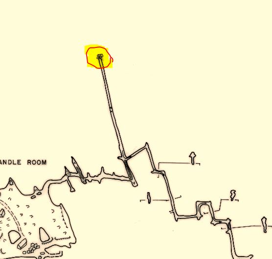
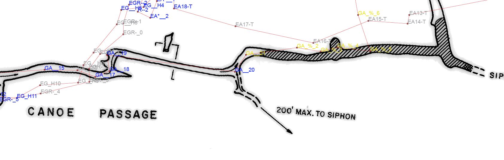
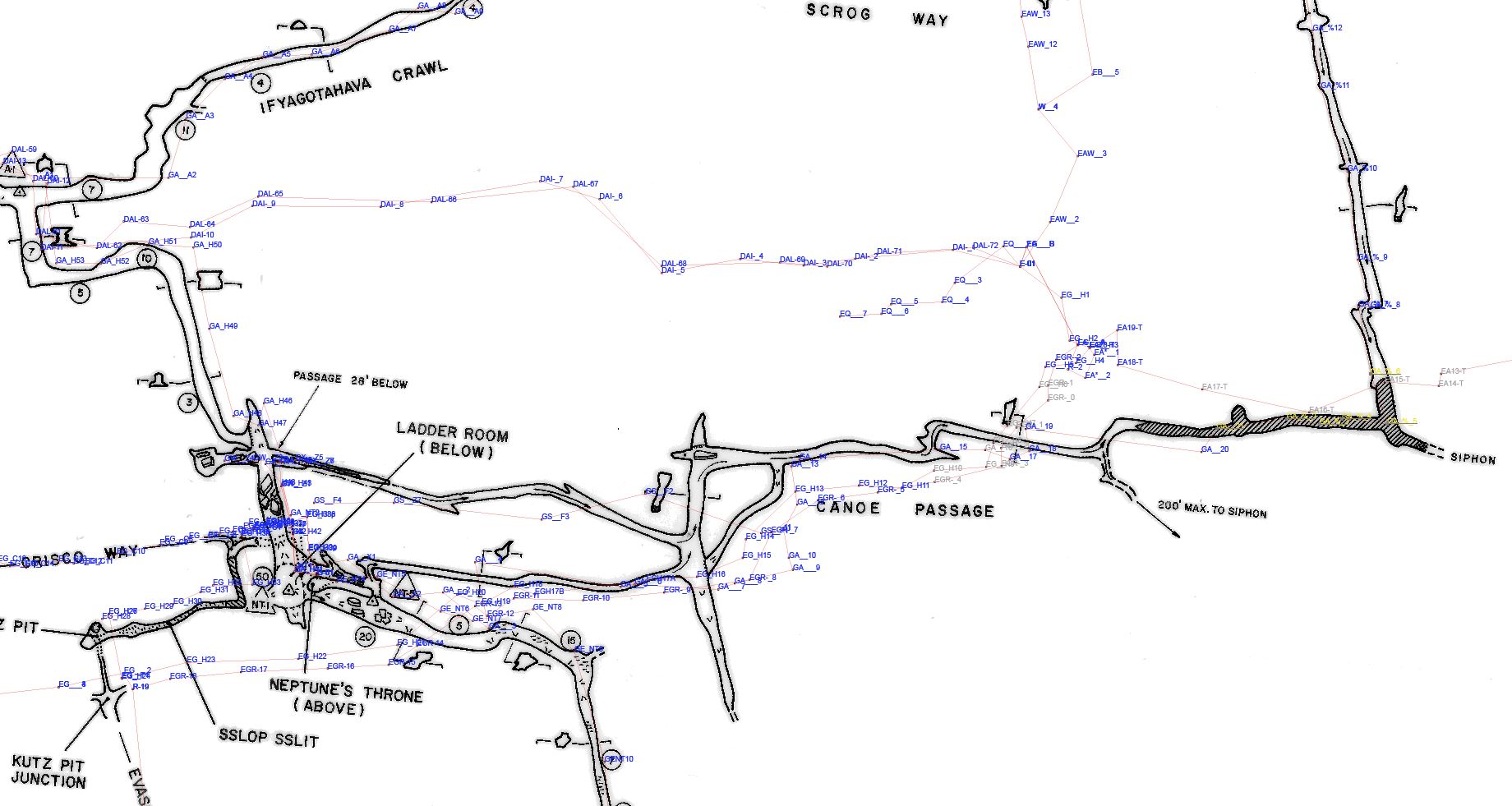
BL-54 Survey unsurveyed '200 feet to siphon' off Canoe Passage ADDED 2017-01-16
The Les Good section map #10 notes an unsurveyed '200 feet to siphon' branching off the Canoe Passage. Tie into station 20. Here is a detail map, and an overview map. And the survey notes.
Could combine BL-46, BL-53, BL-54, BL-55, BL-56, and BL-57.
BL-55 Check siphons in Marlboro Country (Good Sectional #10) for potential dives ADDED 2017-01-16
There are 5 obvious siphons in on Good Sectional #10 without notations about why they are not passable. Little map here. Check and document why they are blocked. Just in case, take a mask and a good light, and be prepared to sumerse yourself for a 30 second underwater check.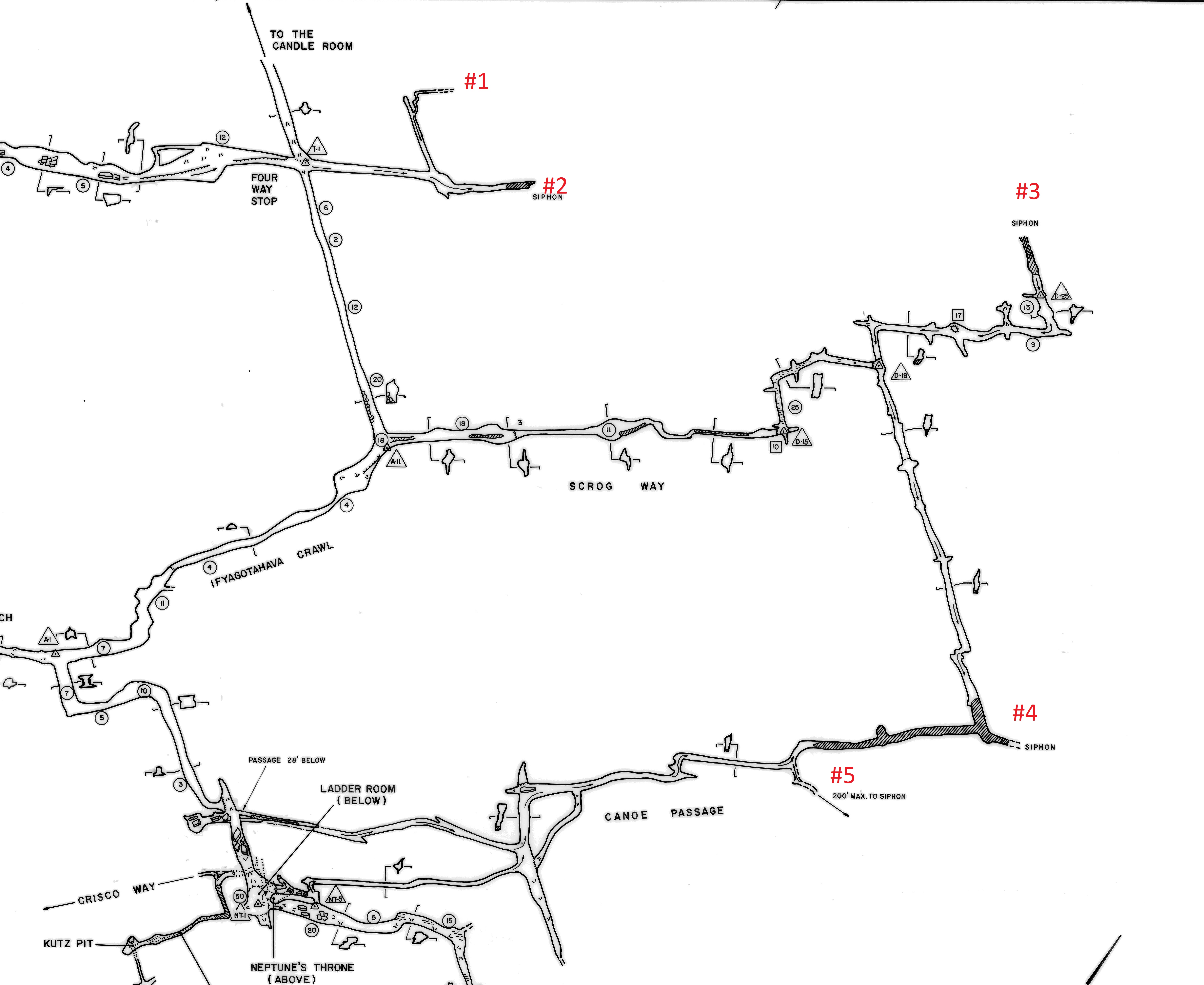
Could combine BL-46, BL-53, BL-54, BL-55, BL-56, and BL-57.
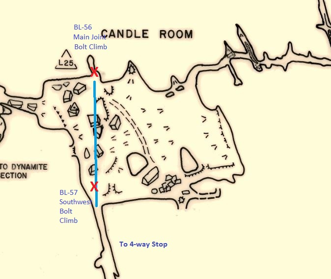
BL-56 "Main Joint" Bolt climb in Candle Room ADDED 2017-01-16
In November 2015, Brian Mayfield and Tony Canike spotted a promising bolt climb in the Candle Room. Here's a photo Tony took in May 2016 during a trip to set dye traps. They intend to climb it December 2016. Note that the bolt climb appears to be in the same joint with the passage that comes in from the Four-Way Stop, so let's call this the "Main Joint Bolt Climb." The Good map doesn't show the alignment; this little map has a blue line that estimates the joint in the ceiling that crosses the whole Candle Room.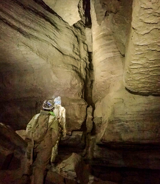
Could combine BL-46, BL-53, BL-54, BL-55, BL-56, and BL-57.
BL-57 "Southwest" Bolt climb in Candle Room ADDED 2017-02-10 STARTED, NOT FINISHED.
On January 21, 2017, a team went to climb the "Main Joint" climb in the Candle Room, but decided to do this "Southwest" climb instead. They almost got to the top and set an anchor, and someone free climbed the remaining dirt slope and found 50' of passage and a lead. There is a traverse at the top to finish to the right (north) to another lead across the joint/drop they plan to return to rig. See this little map.Could combine BL-46, BL-53, BL-54, BL-55, BL-56, and BL-57.
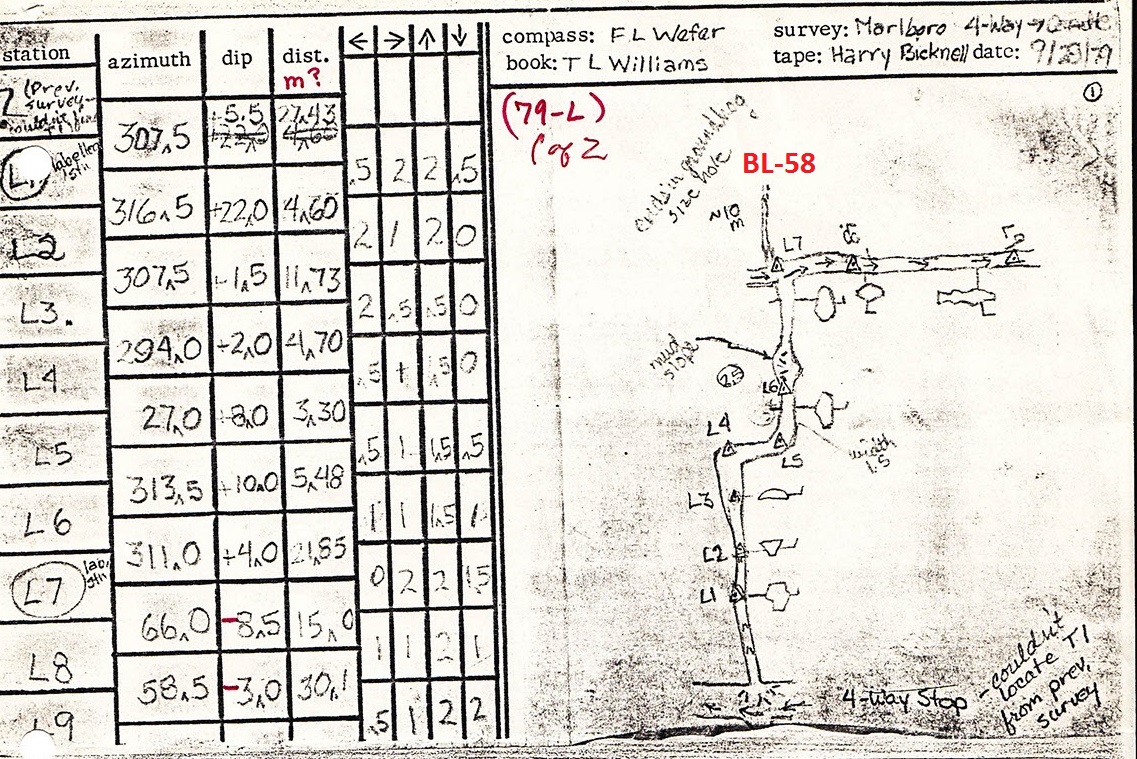
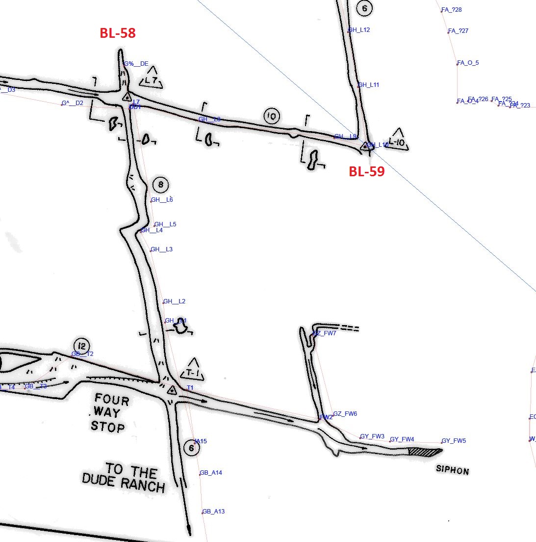
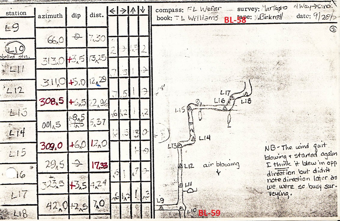
BL-58 "L-7" or "L7" Lead near Candle Room ADDED 2017-02-12
The survey notes from the September 29, 1979 survey trip note an ground hog sized hole just NW of station L7 (or L-7). Check for air or if it is worth mining. Section 11 of the Les Good maps show this too. Brief trip report from 9/29/1979.
Could combine BL-58 and BL-59.
BL-59 "L-10" or "L10" Lead near Candle Room ADDED 2017-02-12
The survey notes from the September 29, 1979 survey trip show an open lead heading SE at station L10 (or L-10). Section 11 of the Les Good maps show this too. Brief trip report from 9/29/1979.
Could combine BL-58 and BL-59.
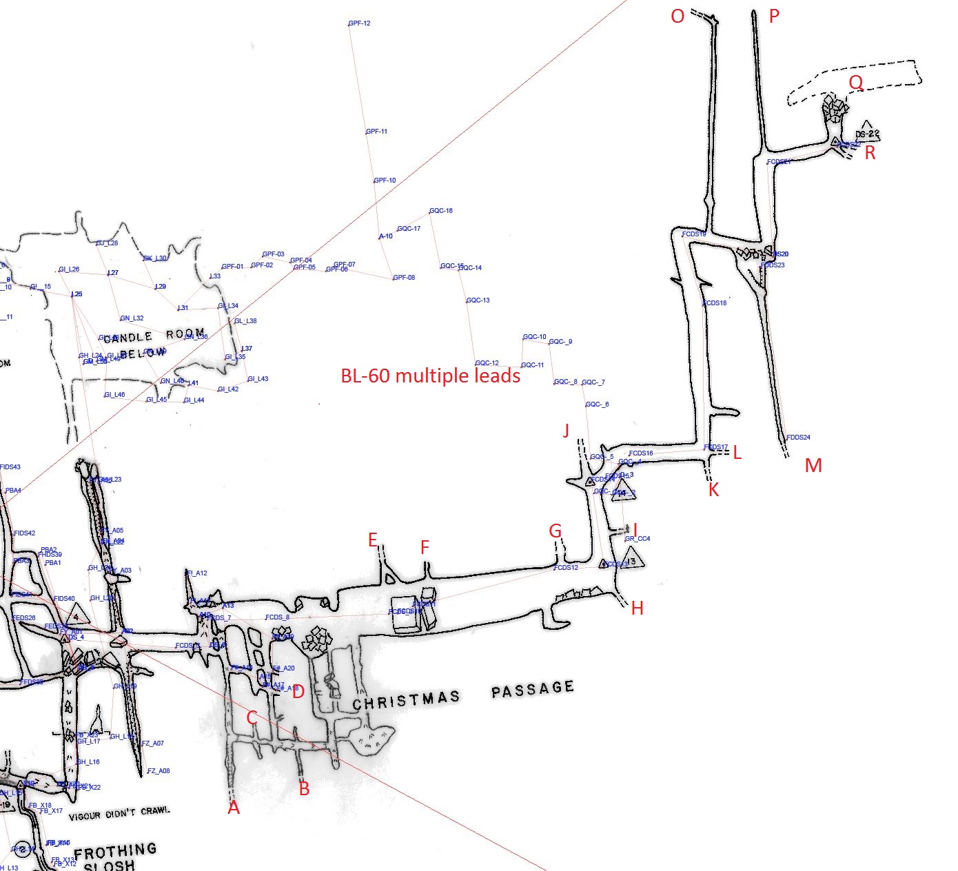
BL-60 Multiple Leads in the Christmas Passage ADDED 2017-02-12
There are numerous open leads shown on the map. Nice formations in that area too. Survey notes say sandstone boulders breakdown above station DS22.
Could combine BL-60 and BL-61.
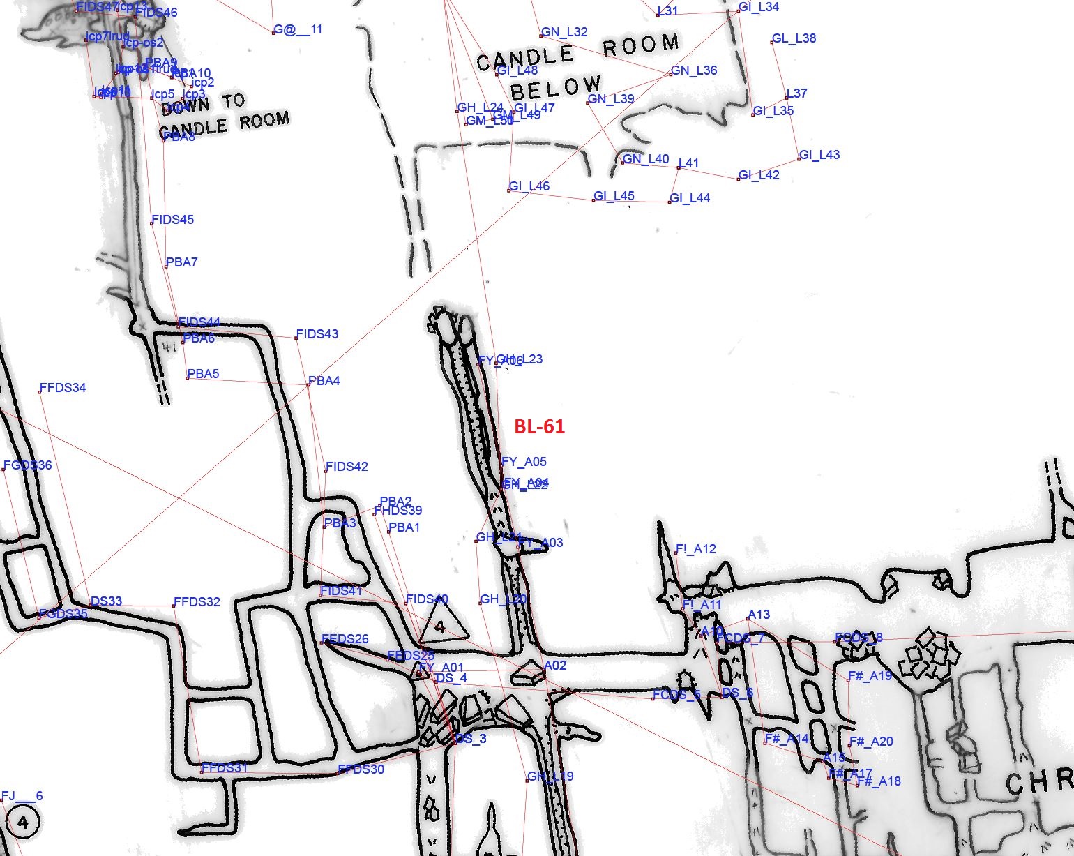
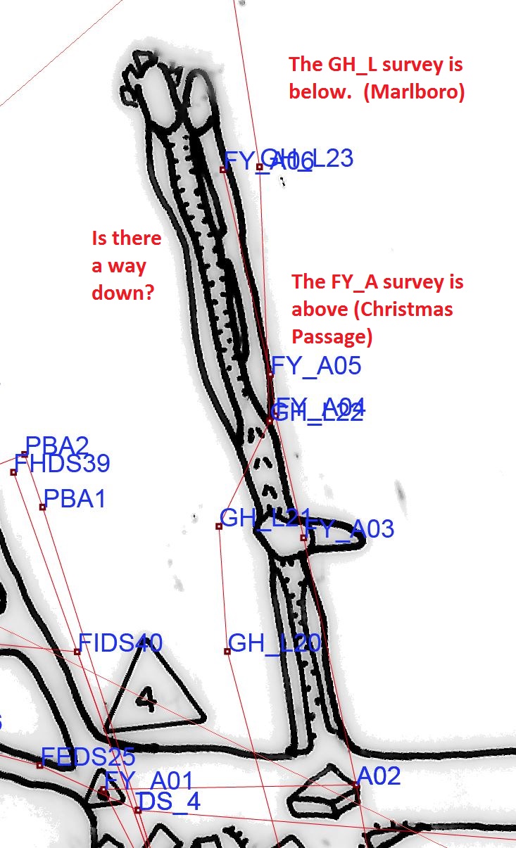
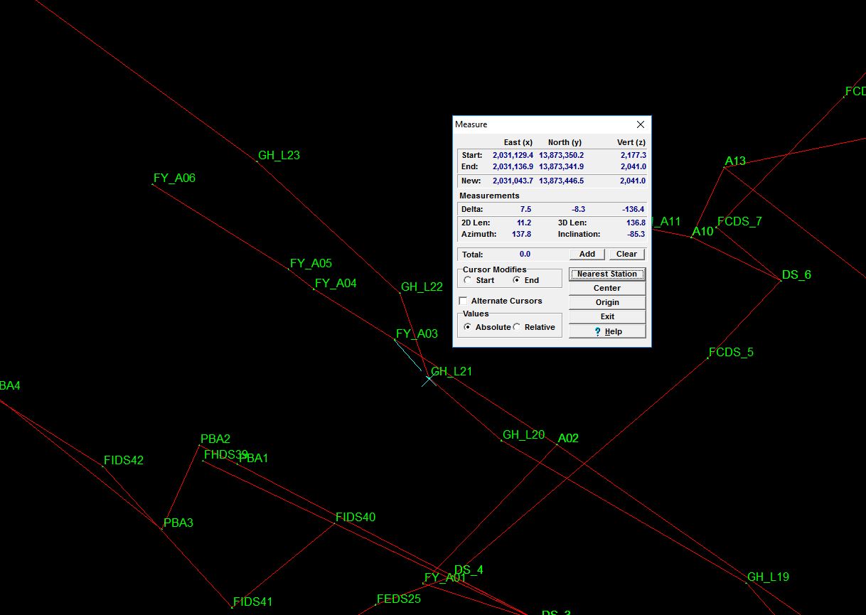
BL-61 Is there a "Better Way" down from the Christmas Passage to the Candle Room? ADDED 2017-02-12
In February 2017, Nate Walter and Tony Canike noted that a side passage off the Christmas Passage is almost immediately over the passage heading to the Candle Room from 4-Way Stop, and the maps note breakdown and complex passage on both levels. It's a long shot, but worth half an hour checking out, as it could be an even easier way to the Candle Room. Vertical distance is 137'. Locator map. Detail Map. Compass measurement.
Could combine BL-60 and BL-61.
BL-62 Cleanup maze bewteen Christmas Passage, Idaho, and Goodway. ADDED 2017-02-12
There is lots of fissurey maze passage in this area that is on the map and not surveyed. There is also bits passage not on the map that needs to be surveyed.
On a second map, there are three leads to push and a lower level at the junction to check out.
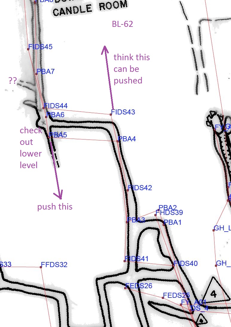
Could combine BL-60 and BL-61.
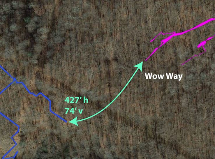
BL-63 Test Potential Air Connection between Wheeland and the Barberry Wow Way. ADDED 2017-12-19
Perform a reversing air experiment to test a potential air connection, as suggested by Aaron Clair, given the proximity of the two cave passages. See BL-64 for more details.
BL-64 Potential Wheeland Connection to Barberry Wow Way. ADDED 2017-12-19
Investiage potential connection between Wheeland and the Barberry Wow Way. Note the proximity between the two in this map. Wheeland is off the Crystal Gallery as shown on this snip of section 2 of the Good Maps.
In personal communication on December 10, 2017, Nate Walter reported to Tony Canike that he and Nevin Davis used a self-drive anchor set on an earlier trip to check out a mid-level lead in the Wheeland dome, but the the whole dome had not been climbed. Nate suggested climbing the whole dome and checking out the high-level canyon extent above the passage just as you enter the dome. Nate also said that he has heard water running behind flowstone on the walls of the dome and perhaps there's passage behind the flowstone.
On December 16, 2017, Eric Pelkey led a team to climb the Wheeland Dome, here is Eric's report. Aaron Clair, who was also on the trip, offered this addendum to Eric's report.
BL-65 Squashed Boob Squeeze area. ADDED 2022-03-11
As a specific resurvey need for BL-30, resurvey from the Upstream Maze to and through Squashed Boob Squeeze. Check and survey leads along the way and/or continue south east towards the Rotunda Room. Ideally tie into at least two modern stations set for BL-26 if you get that far.
Start at and tie into at least two modern stations at or very close to W-12. One of the stations right there was the tip of a standing rock IIRC, tie into it and other stations in case it got knocked about. W-12 (or a station nearby) was connected to for the survey of the shortcut to the Rotunda Room and Wind Dig, see BL-26 for tie-in information. Specifically, shortcut number three on this map was dug open and surveyed. You can see W-12 on the map in the middle of a 6-way junction.
BL-66 Upstream Maze to Huntleys. ADDED 2022-03-11
As a specific resurvey need for BL-30, resurvey a passage from the Upstream Maze to Huntleys Section
Start at and tie into at least two modern stations at or very close to W-12. One of the stations was the tip of a standing rock IIRC, tie into it and other stations in case it got knocked about. W-12 (or a station nearby) was connected to for the survey of the shortcut to the Rotunda Room and Wind Dig, see BL-26 for tie-in information. Specifically, shortcut number three on this map was dug open and surveyed. You can see W-12 on the map in the middle of a 6-way junction.
Then survey northwest until you get to modern (2015 or later) stations in Huntleys around KA27 or 31H. Tie into at least two modern stations.
You can find KA27 and 31H on this map. There was a resurvey done in that area sometime after 2015 but the data manager is a slacker and the notes are still buried in the paper files. You should be able find new stations (whiteout and new flagging) in that area.
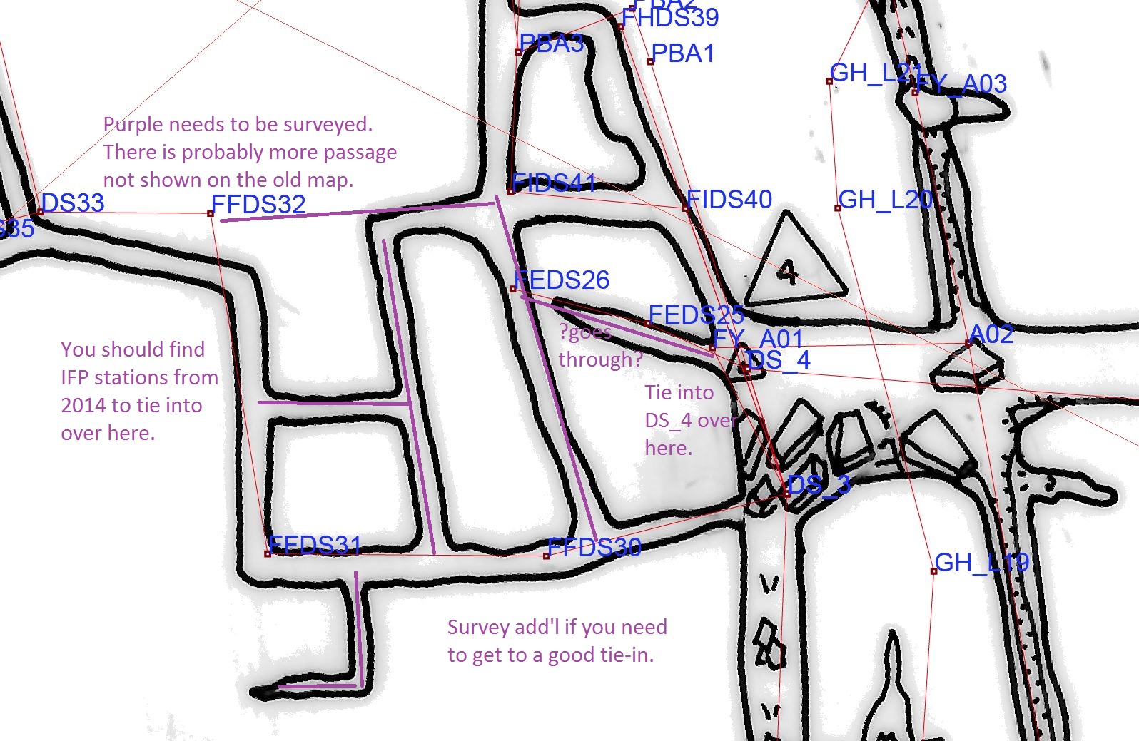
BL-67 Resurvey SOFA Entrance to Sand Canyon. ADDED 2022-03-28
Resurvey from the SOFA Entrance to Sand Canyon.
Tie into:
- The lock on the SOFA door (Nevin used that in the past).
- (if possible) the B-H station at the drop-off to Rotten Rock Falls. I suspect this station has long been kicked over, but take a look for it. Perhaps go down Rotten Rock and find a station.
- The to-be-done resurvey from Complaint (see BL-40)
- B-13 near the Rimstone Pools
- B-01 (NOT B-1) in Sand Canyon
- One of the 2016 AYG stations.
See also BL-40 and BL-68. BL-40 has a little annotated map you might find helpful.
BL-68 Tie the SOFA Entrance to the above ground survey. ADDED 2022-03-28
Take a few survey shots to tie in the SOFA Entrance to the above ground preserve survey. Can be done with cave surveying equipment or a land surveyor's total station.
Tie into two cave survey stations:
- A new station in Dave's Gallery from the BL-67 survey.
- The lock on the SOFA door survey
Run a traverse to the iron rod with blue flagging located under the walnut tree near the shower. Also run a traverse tothe new (March 2022) pin with pink flagging a few feet off the driveway (NOT in the driveway) near Sand Spring.
Completed Exploration Projects
BL-1. Kutz's Pit Anemometer Experiment - posted 10/31/2010, COMPLETED 11/20/2010
Update: This project was successfully completed by Nevin Davis and his team. Report here. Nevin's subsequent analysis shows a clear air connection between Backyard Cave and both arms of Evasor Gallery. The Left-Left Dig is the left arm of Evasor Gallery, BL-3
After the success of the August 31, 2010 air connection experiment, Nevin has suggested that we perform another air experiment between Backyard and Evasor Gallery, but this time setup anemometers in multiple passages near the Kutz's Pit 4-way junction to determine which part of Evasor Gallery has the air connection to Backyard. This also requires the placement of a fan in the entrance to Backyard Cave.
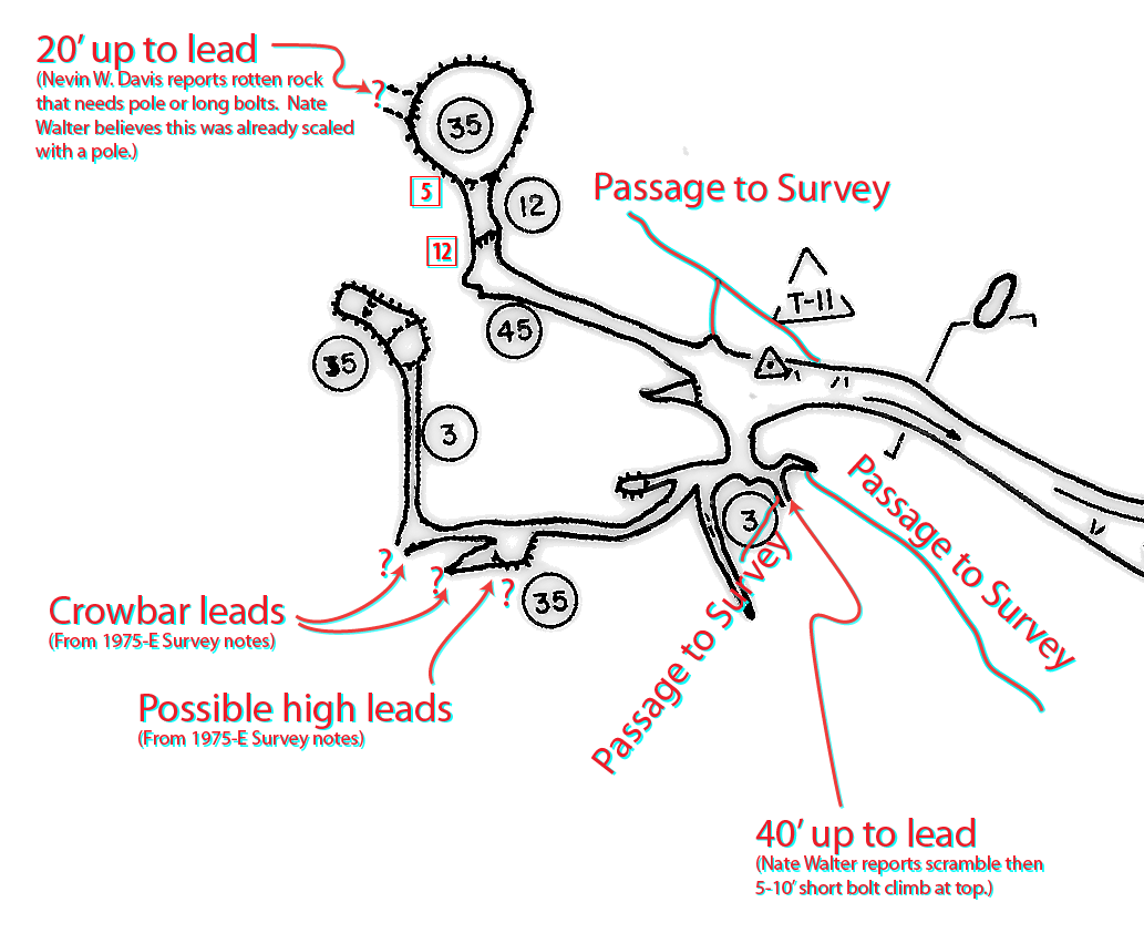
BL-2. Evasor Dome Area - Clean up survey and lead checking -- posted 10/31/2010. COMPLETED 11/20/2010, Updated 6/11/2011.
Nate Walter had reported that there is passage in the same area near T11 that needed to be surveyed, and a number of leads to check in this general area. On 11/20/2010, Nate, Terrance Lovell, John Groh, and Maria Andrews surveyed the loop around T-11, and they (without Maria) surveyed passage going to the "40' up to lead" in the map snipped below (this passage is now called "President's Regret" as Gregg Clemmer and Nevin Davis poo-pooed surveying it many years ago while looking at it.) Anyway, Nate, Terrance, and John reported a definite bolt climb. This climb has since been begun by Canike, Walter, Cooper, and Vargas on January 8, 2011, and it was named the "Cock-eyed Climb."'
For your reference, I've included scans of 1975 survey by Shifflett, Igoe, and Hale, along with a working map from that data.
BL-4. Greaserack Bolt Climb - posted 6/27/2010, updated August 2010. COMPLETED.
Above station A11 in the Greaserack is a tantalizing shadow high up by the ceiling that would need bolt climbing or a scaling pole to reach. I don't remember who first told me about it - perhaps Al Grimm and Scott Olson on a trip out Mbagintao trail in 2007?
On July 5, 2008 Al Grimm, Nat Hirneisen, Scott Olsen, and Tony Canike took a recon trip to the Greaserack to assess what would be needed to climb it. Here is the trip report from that recon trip.
On Saturday July 3, 2010 a bolt climb was completed by Mark Minton, Vonny Droms, Brad Cooper, and Tony Canike. Here is Mark's Trip Report.
The Greaserack is on the trail to Mbagintao, and hence you must wade Penn State Lake to reach it. Here are three maps
Map of the route from Sand Canyon to Penn State Lake
Map of the route from Penn State Lake to the Greaserack
Detailed map of the Greaserack area and survey station tie-ins. The climb itself is above station A11. There is a chimney to the left (SW) of station NA__A9 that might lead to the same place as the bolt climb.
BL-6. Tie in down to the Bean Room from the Balcony Overlook and the Bean Room step across - posted 1/9/2010, updated 4/1/2010, updated 10/31/2010. COMPLETED.
There are two overlooks, one above the other, that look down into the Bean Room. We can tie these in to get a more accurate dimensions of the Bean Room. This is highlighted with two red double-headed arrows, as we need to make two different shots from the two different levels. . Thanks to Nate Walter for the suggestion. Please reference this map.
On April 24, 2010, this survey was completed by Scott Olson, Maret Maxwell, Brad Cooper, and Tony Canike.
BL-7. Survey the passage between the Breakdown Mountain passage and the Balcony Overlook- posted 3/13/2010, updated 4/1/2010, updated 10/31/2010. COMPLETED.
Connect the survey in the Breakdown Mountain passage to the survey in the passage above (NW) of the Bean Room. Shown via a purple double-headed arrow. Please reference this map.
On April 24, 2010, this survey was completed by Scott Olson, Maret Maxwell, Brad Cooper, and Tony Canike.
BL-8. Tie in the KSI7 overlook down to the Bean Room - posted 4/1/2010, updated 10/31/2010. COMPLETED.
The KSI survey by Keith Christenson, Scott Olson, and Istvan on 5/25/1998 documented another overlook into the Bean Room from the passage near station KSI7. This can be tied in with a simple shot or two. This is highlighted on the map by a Teal double-headed arrow. KSI7 is really easy to get to, just a few minutes from the Rimstone Dams. Thanks to Nate Walter for this suggestion. Please reference this map.
On April 24, 2010, this survey was completed by Scott Olson, Maret Maxwell, Brad Cooper, and Tony Canike.
BL-9. SEG Passage to Difficulty Creek- posted 1/6/2010, updated 1/24/2010, updated 10/31/2010. COMPLETED.
Near station 56 on Les's section #1 map, there is a rectilinear "maze" and a narrow passage that trends north west towards the Breakdown Mountain passage and Phil's ladder. There is no record of this ever being surveyed. I've highlighted it with a green dashed line. Tying in this new survey at both ends is important, the tie-in stations could be B-9 and 56. Please reference this map.
UPDATE 1/24/2010: The SEG Passage was partially surveyed on 1/16/2010, from the lower passage near Phil's Ladder down to and past Santa Pit to the end. The survey needs to be continued by dropping the pit and surveying towards station 56. Could combine this trip with the above-mentioned Bottom of the Bean Room survey. The survey team was Nevin W. Davis, Nate Walter, Sara Good, and Tony Canike.
UPDATE 10/31/2010: The SEG Passage survey was completed on 4/10/2010 by Nevin W. Davis, Nate Walter, Sara Good, Nathan Farrar, and Tony Canike.
BL-10. PBR Loop Mining Connection - posted 12/17/2009, updated 10/31/2010. COMPLETED.
Here is a location in the cave very close to our dig that needs a little bit of survey. This map is a collage of the Les Good Butler Section Map #1 from ca. 1985 and the Keith Christenson "Left Turn Through Entrance Sequence" map documenting their 1998 survey. Keith, Scott Olson, and Istvan cleaned up this area very well in 1998, but then Phil went and changed things to make the lead a passable connection by digging open the connection between station n6 and 20r.
Looking at where the orange arrow points, Keith sketched what was a lead going to the right (NbyNE) as a dashed lead, but it now connects to the other passage. And the line plot has been improved since both the 1998 survey and Les's 1985 map, so nothing quite lines up (give me a couple years to fix that ok?)
It's been surveyed with a laser prior to the dig to make it passable, but it has not been sketched to my knowledge. We could use a sketch and a little detail please of the new connection between stations n6 and 20r.
On April 24th, 2010, this passage was surveyed by Ed Kehs, Keith Wheeland, and Natalie Hirneisen.
BL-11. Trunk Channel Bypass Survey - posted 12/17/2009. CANCELED, NOT NEEDED.
6/27/2010 Update: The survey data for this passage has been unearthed, no need to survey this. Canceled.
1/6/2010 UPDATE: (Might be best to hold off on this one until February or March when I hope to have more original survey books from Jeff Uhl and can look for the sketches and LRUD data.
Here is another part of the cave that needs attention by a survey team. The Trunk Channel Bypass is just downstream of the Air Dig. It's been surveyed twice and the DAI (distance, az, incl) data is in Compass, but we are missing the sketches and the LRUD data.
Pages 3 and 4 of a detailed map show the sketched passage on the Les Good Section #5 from the late 1980's, along with the current line plot.
Here is the Compass data for the surveys.
Ignoring the fact that the current line plot doesn't line up with the 20 year old map due to improvements by Nevin and others, there are a couple significant discrepancies between the sketched passage and the line plot that need to be investigated, such the location of the reconnection of the downstream end of the Bypass and the main trunk near station L22(?). The in-cave team will need to decide if they can just sketch on the existing line plot, or if the passage needs to be resurveyed.
BL-14. High Lead between Snake River and Elephant Graveyard -- posted 6/11/2011, COMPLETED 12/14/2013.
Paul Winter and Nathan Farrar reported orally that that Paul pushed Nathan up into the lead on the way out during their 12/14/2013 Mbagintao trip. There is a high passage up there, but it is quickly plugged by dirt in each direction. On the 7/3/2010 trip to the Greaserack Climb, Mark Minton discovered and began pushing a high lead between Snake River and Elephant Graveyard. Here is Mark's Trip Report.
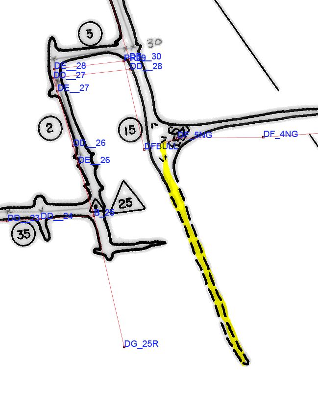
BL-26. Dig open and Survey the Shortcut to the Rodunda Room and Wind Dig - posted 9/21/2013. COMPLETED 3/14/2014.
Update #2: The shortcut was surveyed on March 14, 2014.
The shortcut dug open on 7/5/2013 needs to be surveyed. This is important as it will close a loop in the mazy area with many bad loops.
Update: The shortcut was successfully dug open by Mark Minton, Yvonne Droms, Zeb Lilly, and Tony Canike on Friday July 5, 2013. We dug open option #3 on the maps linked to below. Mark's trip report from 7/5/2013 is here.
As there are a number leads to work near the Rotunda Room, we are looking for a short cut from the Natural Bridge to the Rotunda Room. The currently known two routes are head towards Penn State Lake and then head up through Cathy's Crawl, or to do the long Squashed Boob Squeeze loop. There appear to be three possible connections through breakdown that might only require moving a couple rocks. There is a fourth possible route through previously-surveyed passage that runs below the Rotunda Room. In recent history, we've poked at this once from each end, but did not seriously push it. The Compass data says it connects. Here's a map, the green line shows the Cathy's Crawl route we took on a 5/25/2013 trip, the red line shows the "fourth possible route." The "CLTU?" are possible connect-lower-to-upper shortcuts through breakdown. More map analysis here.
BL-31. Surface radio locate Evasor Gallery - posted 9/21/2013. COMPLETED 11/29/2013
Completed 11/29/2013 by a team of Mark Hodge and Tony Canike in-cave and Nevin Davis and Phil Lucas on the surface. Surface coordinated GPS located by Tony Canike and Nevin Davis on 8/28/2014.
Radio locate Evasor Gallery on the surface and get good GPS coordinates for the location. This was done ca. 1979 but the in-cave radio not tied into the cave survey nor were coordinates determined for the surface point. Use this map for in-cave survey tie-in. This is important as it will improve the accuracy of the location of the whole downstream section, including the ends of Evasor Gallery that run towards other known caves and sinks.
BL-32. Rotated Rectilinear Maze "Idaho"- posted 9/21/2013. COMPLETED 12/13/2014
Update: Paul Winter, Hope Brooks, and Eric Pelkey resurveyed this section on 12/13/2014. Trip report here. They tied-in to old station DS_3 and surveyed to Idaho. Initial analysis of the survey data appears to show that Idaho was indeed rotated due to a prior survey error.
There is a small rectiliear maze section, called Idaho, WNW of the Frothing Slosh, andoff the passage to the Good Way to the Candle Room, that appears to be rotated due to a survey error. Many late-night homestead conversations have pondered whether this is a survey error or if the prevailing joints change direction there. Here's a little map. Could be combined with BL-29.
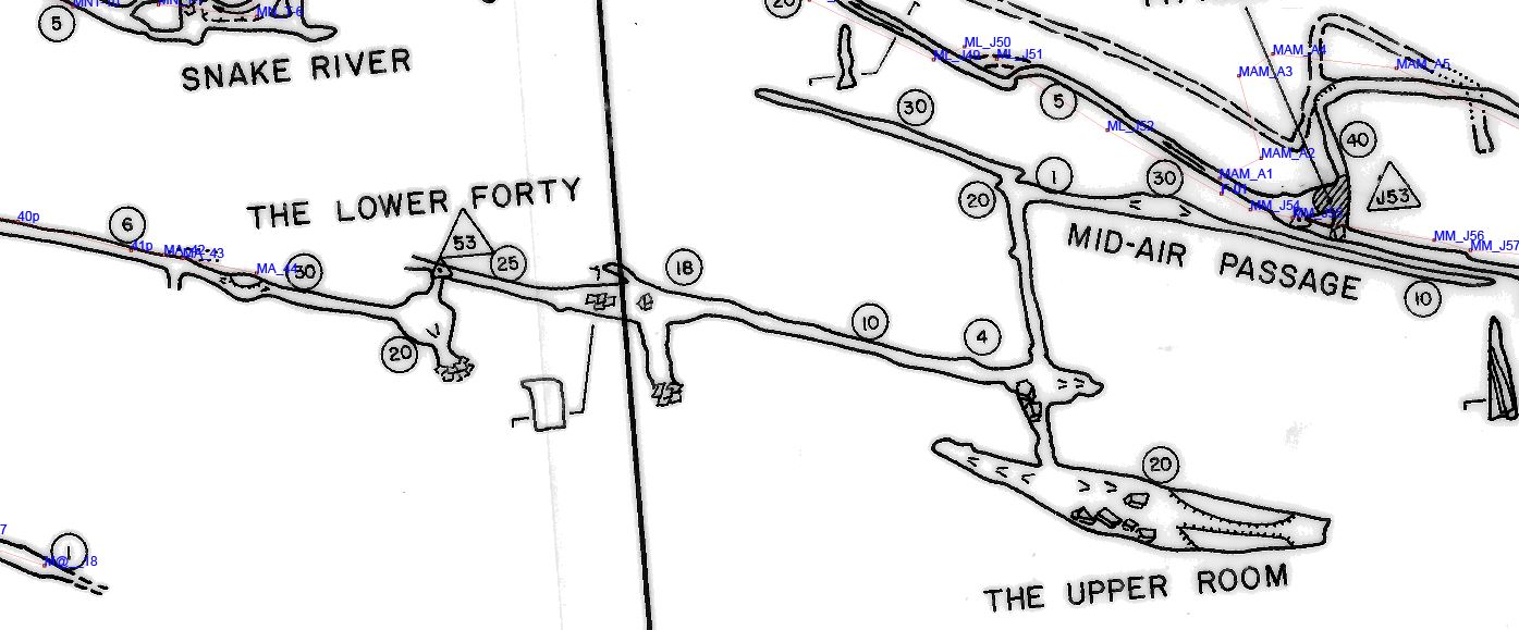
BL-39. Resurvey The Lower Forty, Mid-Air Passage, and The Upper Room ADDED 2014-10-22 UPDATED 3/2/2016 FINISHED
UPDATE: While preparing to hit this lead over the February 2016 project weekend, scouring the Butler survey notes for good tie-in descriptions resulted in locating the survey notes from March 9, 1974 (Phil Lucas, Maret Maxwell, Lee Maurney) for this area. Paul Winter kindly typed the notes in, netting us an additional 0.16 miles.
We are missing data for passages in The Lower Forty, Mid-Air Passage, and The Upper Room. There is probably 700' of passage here. Here's a blowup for the tie-in.